Nickname: Little Witch Island | |
|---|---|
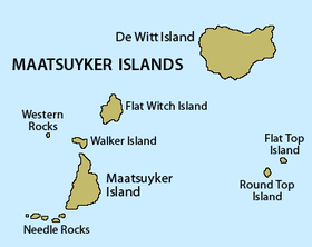
 Detailed map of the Maatsuyker Islands Group, showing Flat Witch Island in the centre. | |
| Geography | |
| Location | South West Tasmania |
| Coordinates | 43°37′12″S 146°17′24″E / 43.62000°S 146.29000°E |
| Archipelago | Maatsuyker Islands Group |
| Adjacent to | Southern Ocean |
| Area | 64 ha (160 acres)[1] |
| Highest elevation | 100 m (300 ft) |
| Administration | |
Australia | |
| State | Tasmania |
| Region | South West |
| Demographics | |
| Population | Unpopulated |
Flat Witch Island, also known as Little Witch Island, is an island located close to the south-western coast of Tasmania, Australia. The 64-hectare (0.25 sq mi) island is part of the Maatsuyker Islands Group, and comprises part of the Southwest National Park and the Tasmanian Wilderness World Heritage Site.[1][2]
The island's highest point is 100 metres (330 ft) above sea level.
- ^ a b "Small Southern Islands Conservation Management Statement 2002" (PDF). Tasmania Parks and Wildlife Service. 2002. Archived from the original (PDF) on 22 August 2006. Retrieved 20 July 2006.
- ^ Brothers, Nigel; Pemberton, David; Pryor, Helen; & Halley, Vanessa. (2001). Tasmania’s Offshore Islands: seabirds and other natural features. Tasmanian Museum and Art Gallery: Hobart. ISBN 0-7246-4816-X
