Flatanger Municipality
Flatanger kommune | |
|---|---|
 | |
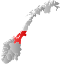
 Trøndelag within Norway | |
 Flatanger within Trøndelag | |
| Coordinates: 64°25′11″N 10°54′28″E / 64.41972°N 10.90778°E | |
| Country | Norway |
| County | Trøndelag |
| District | Namdalen |
| Established | 1 Jan 1871 |
| • Preceded by | Fosnes Municipality |
| Administrative centre | Lauvsnes |
| Government | |
| • Mayor (2011) | Olav Jørgen Bjørkås (Sp) |
| Area | |
• Total | 458.71 km2 (177.11 sq mi) |
| • Land | 433.53 km2 (167.39 sq mi) |
| • Water | 25.18 km2 (9.72 sq mi) 5.5% |
| • Rank | #216 in Norway |
| Highest elevation | 611.49 m (2,006.20 ft) |
| Population (2024) | |
• Total | 1,116 |
| • Rank | #326 in Norway |
| • Density | 2.4/km2 (6/sq mi) |
| • Change (10 years) | |
| Demonym | Flatangring[2] |
| Official language | |
| • Norwegian form | Neutral |
| Time zone | UTC+01:00 (CET) |
| • Summer (DST) | UTC+02:00 (CEST) |
| ISO 3166 code | NO-5049[4] |
| Website | Official website |
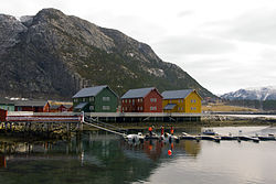
Flatanger is a municipality in Trøndelag county, Norway. It is part of the Namdalen region. The administrative centre of the municipality is Lauvsnes. Other villages include Jøssund, Hasvåg, and Vik.
The 459-square-kilometre (177 sq mi) municipality is the 216th largest by area out of the 357 municipalities in Norway. Flatanger is the 326th most populous municipality in Norway with a population of 1,116. The municipality's population density is 2.4 inhabitants per square kilometre (6.2/sq mi) and its population has decreased by 0.4% over the previous 10-year period.[5][6]
Flatanger is also known for having some of the most difficult sport climbing routes in the world.
- ^ "Høgaste fjelltopp i kvar kommune" (in Norwegian). Kartverket. 16 January 2024.
- ^ "Navn på steder og personer: Innbyggjarnamn" (in Norwegian). Språkrådet.
- ^ "Forskrift om målvedtak i kommunar og fylkeskommunar" (in Norwegian). Lovdata.no.
- ^ Bolstad, Erik; Thorsnæs, Geir, eds. (26 January 2023). "Kommunenummer". Store norske leksikon (in Norwegian). Kunnskapsforlaget.
- ^ Statistisk sentralbyrå. "Table: 06913: Population 1 January and population changes during the calendar year (M)" (in Norwegian).
- ^ Statistisk sentralbyrå. "09280: Area of land and fresh water (km²) (M)" (in Norwegian).

