Flathead Indian Reservation | |
|---|---|
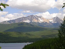
 View northeastward across Hungry Horse Reservoir onto the Flathead Range, Montana | |
 Location in Montana | |
| Coordinates: 47°29′59″N 114°16′46″W / 47.49972°N 114.27944°W | |
| Tribe | Confederated Salish and Kootenai |
| Country | United States |
| State | Montana |
| Counties | Flathead Lake Missoula Sanders |
| Established | 1855 |
| Headquarters | Pablo |
| Government | |
| • Body | Tribal Council |
| • Chairman | Michael Dolson |
| • Vice-Chairman | Tom McDonald |
| Area | |
| • Total | 5,020 km2 (1,938 sq mi) |
| Population (2017)[2] | |
| • Total | 29,218 |
| • Density | 5.8/km2 (15/sq mi) |
| Time zone | UTC-7 (MST) |
| • Summer (DST) | UTC-6 (MDT) |
| Website | cskt.org |
The Flathead Indian Reservation, located in western Montana on the Flathead River, is home to the Bitterroot Salish, Kootenai, and Pend d'Oreilles tribes – also known as the Confederated Salish and Kootenai Tribes of the Flathead Nation. The reservation was created through the July 16, 1855, Treaty of Hellgate.
It has land in four of Montana's counties: Lake, Sanders, Missoula, and Flathead, and controls most of Flathead Lake.[3] The Flathead Indian Reservation, west of the Continental Divide, consists of 1,938 square miles (5,020 km2) (1,317,000 acres (533,000 ha)) of forested mountains and valleys.[4]
- ^ "Government – Tribal Council". Retrieved July 24, 2019.
- ^ 2013-2017 American Community Survey 5-Year Estimates. "My Tribal Area". United States Census Bureau.
{{cite web}}: CS1 maint: numeric names: authors list (link) - ^ Cite error: The named reference
lakecowas invoked but never defined (see the help page). - ^ Cite error: The named reference
ohwywas invoked but never defined (see the help page).
