This article needs additional citations for verification. (February 2013) |
Flaxweiler
Fluessweiler (Luxembourgish) | |
|---|---|
 | |
 Map of Luxembourg with Flaxweiler highlighted in orange, and the canton in dark red | |
| Coordinates: 49°39′55″N 6°20′35″E / 49.6653°N 6.3431°E | |
| Country | |
| Canton | Grevenmacher |
| Government | |
| • Mayor | Paul Ruppert |
| Area | |
| • Total | 30.17 km2 (11.65 sq mi) |
| • Rank | 26th of 100 |
| Highest elevation | 387 m (1,270 ft) |
| • Rank | 63rd of 100 |
| Lowest elevation | 208 m (682 ft) |
| • Rank | 28th of 100 |
| Population (2023) | |
| • Total | 2,193 |
| • Rank | 70th of 100 |
| • Density | 73/km2 (190/sq mi) |
| • Rank | 79th of 100 |
| Time zone | UTC+1 (CET) |
| • Summer (DST) | UTC+2 (CEST) |
| LAU 2 | LU0001103 |
| Website | flaxweiler.lu |
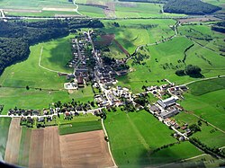
Flaxweiler (Luxembourgish: Fluessweiler) is a commune and small town in south-eastern Luxembourg. It is part of the canton of Grevenmacher.
As of 2024[update], the town of Flaxweiler, which lies in the north-west of the commune, has a population of 593.[1] Other towns within the commune include Beyren, Gostingen, Niederdonven, and Oberdonven.
- ^ "Registre national des personnes physiques RNPP : Population par localité". data.public.lu. 2024-01-07.
