Flemington, New Jersey | |
|---|---|
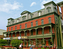
 Union Hotel in downtown Flemington | |
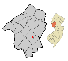
 Location of Flemington in Hunterdon County highlighted in red (left). Inset map: Location of Hunterdon County in New Jersey highlighted in orange (right). | |
 | |
Location of Flemington in Hunterdon County, New Jersey Location of Flemington in New Jersey | |
| Coordinates: 40°30′31″N 74°51′36″W / 40.508641°N 74.859869°W[1][2] | |
| Country | |
| State | |
| County | Hunterdon |
| Incorporated | April 26, 1910 |
| Named for | Samuel Fleming |
| Government | |
| • Type | Borough |
| • Body | Borough Council |
| • Mayor | Marcia A. Karrow (R, term ends December 31, 2026)[3][4] |
| • Municipal clerk | Carla Conner[5] |
| Area | |
• Total | 1.08 sq mi (2.79 km2) |
| • Land | 1.08 sq mi (2.79 km2) |
| • Water | 0.00 sq mi (0.00 km2) 0.00% |
| • Rank | 494th of 565 in state 22nd of 26 in county[1] |
| Elevation | 180 ft (50 m) |
| Population | |
• Total | 4,876 |
• Estimate (2023)[10] | 4,902 |
| • Rank | 381st of 565 in state 8th of 26 in county[11] |
| • Density | 4,514.8/sq mi (1,743.2/km2) |
| • Rank | 130th of 565 in state 1st of 26 in county[11] |
| Time zone | UTC−05:00 (Eastern (EST)) |
| • Summer (DST) | UTC−04:00 (Eastern (EDT)) |
| ZIP Code | |
| Area code | 908[14] |
| FIPS code | 3401923700[1][15][16] |
| GNIS feature ID | 885220[1][17] |
| Website | www |
Flemington is a borough in and the county seat of Hunterdon County, in the U.S. state of New Jersey.[18] Most of the borough is located in the Amwell Valley, a low-lying area of the Newark Basin, and the Raritan Valley, the South Branch of the Raritan River, which flows through the center of Flemington. Northwestern portions of the borough sit on the Hunterdon Plateau. As of the 2020 United States census, the borough's population was 4,876,[9] its highest decennial count ever and an increase of 295 (+6.4%) from the 2010 census count of 4,581,[19][20] which in turn reflected an increase of 381 (+9.1%) from the 4,200 counted in the 2000 census.[21]
Flemington is an independent municipality completely surrounded by Raritan Township and is located near the geographic center of the township. Flemington was incorporated as an independent borough by an act of the New Jersey Legislature on April 7, 1910, based on the results of a referendum held on April 26, 1910, and was formally separated from Raritan Township.
- ^ a b c d 2019 Census Gazetteer Files: New Jersey Places, United States Census Bureau. Accessed July 1, 2020.
- ^ US Gazetteer files: 2010, 2000, and 1990, United States Census Bureau. Accessed September 4, 2014.
- ^ Cite error: The named reference
Officialswas invoked but never defined (see the help page). - ^ 2023 New Jersey Mayors Directory, New Jersey Department of Community Affairs, updated February 8, 2023. Accessed February 10, 2023.
- ^ Borough Clerk, Borough of Flemington. Accessed November 19, 2023.
- ^ Cite error: The named reference
DataBookwas invoked but never defined (see the help page). - ^ "ArcGIS REST Services Directory". United States Census Bureau. Retrieved October 11, 2022.
- ^ U.S. Geological Survey Geographic Names Information System: Borough of Flemington, Geographic Names Information System. Accessed March 5, 2013.
- ^ a b Cite error: The named reference
LWD2020was invoked but never defined (see the help page). - ^ Cite error: The named reference
PopEstwas invoked but never defined (see the help page). - ^ a b Population Density by County and Municipality: New Jersey, 2020 and 2021, New Jersey Department of Labor and Workforce Development. Accessed March 1, 2023.
- ^ Look Up a ZIP Code for Flemington, NJ, United States Postal Service. Accessed August 7, 2012.
- ^ Zip Codes, State of New Jersey. Accessed August 28, 2013.
- ^ Area Code Lookup - NPA NXX for Flemington, NJ, Area-Codes.com. Accessed October 12, 2013.
- ^ U.S. Census website, United States Census Bureau. Accessed September 4, 2014.
- ^ Geographic Codes Lookup for New Jersey, Missouri Census Data Center. Accessed April 1, 2022.
- ^ US Board on Geographic Names, United States Geological Survey. Accessed September 4, 2014.
- ^ New Jersey County Map, New Jersey Department of State. Accessed December 1, 2022.
- ^ Cite error: The named reference
Census2010was invoked but never defined (see the help page). - ^ Cite error: The named reference
LWD2010was invoked but never defined (see the help page). - ^ Table 7. Population for the Counties and Municipalities in New Jersey: 1990, 2000 and 2010, New Jersey Department of Labor and Workforce Development, February 2011. Accessed May 1, 2023.


