Flinders Lane | |
|---|---|
 | |
| Flinders Lane | |
 | |
| Coordinates | |
| General information | |
| Type | Street |
| Length | 2 km (1.2 mi) |
| Major junctions | |
| West end | Melbourne CBD |
| East end | Spring Street Melbourne CBD |
| Location(s) | |
| LGA(s) | City of Melbourne |
| Suburb(s) | Melbourne CBD |
| ---- | |
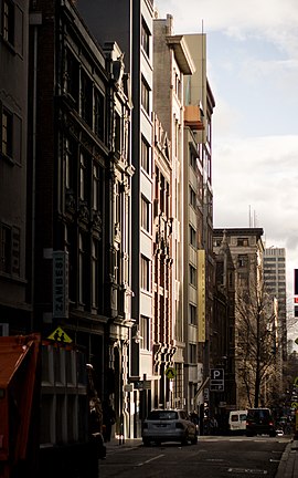
Flinders Lane is a minor street and thoroughfare in the Melbourne central business district of Victoria, Australia. The laneway runs east–west from Spring Street to Spencer Street in-between Flinders and Collins streets. Originally laid out as part of the Hoddle Grid in 1837, the laneway was once the centre of Melbourne's rag trade and is still home to boutique designers and high-end retailers including Chanel, now perched alongside numerous upscale hotels like the W Hotel Melbourne and Adelphi Hotel, loft apartments, cafes and bars.[1]
Many historic buildings are found on Flinders Lane with a history of strict height limits helping to preserve the buildings from redevelopment.[2] Despite the loss of some significant buildings over time, it is still known for its SoHo atmosphere and chic, well-preserved historic buildings.[1]
- ^ a b "Flinders Lane :: Punthill Apartments". www.punthill.com.au. Retrieved 19 January 2017.
- ^ Melbourne, School of Historical Studies, Department of History, The University of. "Skyscrapers - Entry - eMelbourne - The Encyclopedia of Melbourne Online". www.emelbourne.net.au. Retrieved 19 January 2017.
{{cite web}}: CS1 maint: multiple names: authors list (link)
