Flora, Indiana | |
|---|---|
 Center Street downtown | |
| Nickname: The Garden Spot of Indiana | |
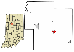
 Location of Flora in Carroll County, Indiana. | |
| Coordinates: 40°32′44″N 86°31′21″W / 40.54556°N 86.52250°W | |
| Country | United States |
| State | Indiana |
| County | Carroll |
| Township | Monroe |
| Area | |
| • Total | 1.15 sq mi (2.97 km2) |
| • Land | 1.15 sq mi (2.97 km2) |
| • Water | 0.00 sq mi (0.00 km2) |
| Elevation | 702 ft (214 m) |
| Population (2020) | |
| • Total | 2,094 |
| • Density | 1,824.04/sq mi (704.27/km2) |
| Time zone | UTC-5 (EST) |
| • Summer (DST) | UTC-5 (EST) |
| ZIP code | 46929 |
| Area code | 574 |
| FIPS code | 18-23692[3] |
| GNIS feature ID | 2396940[2] |
| Website | http://www.townofflora.org/ |
Flora is a town in Monroe Township, Carroll County, Indiana, United States. The population was 2,036 at the 2010 census. It is part of the Lafayette, Indiana Metropolitan Statistical Area.
- ^ "2020 U.S. Gazetteer Files". United States Census Bureau. Retrieved March 16, 2022.
- ^ a b U.S. Geological Survey Geographic Names Information System: Flora, Indiana
- ^ "U.S. Census website". United States Census Bureau. Retrieved 2008-01-31.