Florence, Oregon | |
|---|---|
City | |
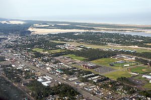
 Aerial view of Florence | |
 Location in Oregon | |
| Coordinates: 43°58′30″N 124°6′9″W / 43.97500°N 124.10250°W | |
| Country | United States |
| State | Oregon |
| County | Lane |
| Incorporated | 1893 |
| Government | |
| • Mayor | Rob Ward[1] |
| Area | |
• Total | 6.22 sq mi (16.11 km2) |
| • Land | 5.53 sq mi (14.33 km2) |
| • Water | 0.69 sq mi (1.78 km2) |
| Elevation | 66 ft (20 m) |
| Population | |
• Total | 9,396 |
| • Density | 1,698.17/sq mi (655.68/km2) |
| Time zone | UTC−8 (Pacific) |
| • Summer (DST) | UTC−7 (Pacific) |
| ZIP Code | 97439 |
| Area code(s) | 458 and 541 |
| FIPS code | 41-26050[5] |
| GNIS feature ID | 2410511[3] |
| Website | www.ci.florence.or.us |

Florence is a coastal city in Lane County, in the U.S. state of Oregon. It lies at the mouth of the Siuslaw River on the Pacific Ocean and about midway between Newport to the north and Coos Bay to the south along U.S. Route 101. As of August 14, 2023, the city had a total population of 9,553.[6][7]
- ^ "City Of Florence Website". 2024. Archived from the original on April 3, 2024. Retrieved April 3, 2024.
- ^ "ArcGIS REST Services Directory". United States Census Bureau. Archived from the original on February 13, 2023. Retrieved October 12, 2022.
- ^ a b U.S. Geological Survey Geographic Names Information System: Florence, Oregon
- ^ Cite error: The named reference
USCensusDecennial2020CenPopScriptOnlywas invoked but never defined (see the help page). - ^ "U.S. Census website". United States Census Bureau. Archived from the original on December 27, 1996. Retrieved January 31, 2008.
- ^ "2019 U.S. Gazetteer Files". United States Census Bureau. Archived from the original on August 27, 2021. Retrieved August 27, 2021.
- ^ "Section 1- Proponent Input" (PDF). August 14, 2023. Archived (PDF) from the original on December 29, 2023. Retrieved December 29, 2023.