This article needs additional citations for verification. (March 2013) |
Florencia | |
|---|---|
 | |
 Florencia municipality (red) within Ciego de Ávila Province (yellow) and Cuba | |
| Coordinates: 22°08′51″N 78°58′1″W / 22.14750°N 78.96694°W | |
| Country | Cuba |
| Province | Ciego de Ávila |
| Area | |
| • Total | 286 km2 (110 sq mi) |
| Elevation | 110 m (360 ft) |
| Population (2022)[2] | |
| • Total | 18,291 |
| • Density | 64/km2 (170/sq mi) |
| Time zone | UTC-5 (EST) |
| Area code | +53-336 |
| Website | https://www.florencia.gob.cu/es/ |
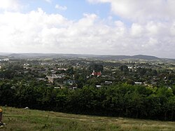
Florencia (Spanish pronunciation: [floˈɾensja]) is a municipality and town in the Ciego de Ávila Province of Cuba. It is located in the western part of the province, south of Chambas. This municipality merged in 1976 as a result of the new political and administrative division of Cuba. Florencia was formerly the barrios of Guadalupe, Tamarindo and Marroquí which were separated from the municipality of Morón.