Native name: Ilha das Flores Nickname: The Yellow Island | |
|---|---|
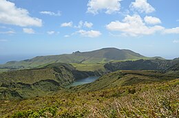
 View of the island's southern side, with the Funda Lake downhill | |
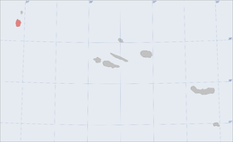
 Location of the island of Flores in the archipelago of the Azores | |
| Geography | |
| Location | Atlantic Ocean |
| Coordinates | 39°26′37″N 31°11′57″W / 39.44361°N 31.19917°W |
| Archipelago | Azores |
| Area | 141.02 km2 (54.45 sq mi)[1] |
| Coastline | 72.79 km (45.23 mi)[1] |
| Highest elevation | 915 m (3002 ft)[1] |
| Highest point | Morro Alto |
| Administration | |
| Autonomous Region | Azores |
| Municipalities | |
| Demographics | |
| Demonym | Florense/Florentino |
| Population | |
| Pop. density | 28.33/km2 (73.37/sq mi)[1] |
| Languages | Portuguese |
| Ethnic groups | Portuguese |
| Additional information | |
| Time zone | |
Flores Island (Portuguese: Ilha das Flores; Portuguese pronunciation: [ˈfloɾɨʃ]) is an island of the Western Group (Grupo Ocidental) of the Azores.
It has an area of 143 km2, a population of 3428 inhabitants, and, together with Corvo Island of the western archipelago, lies within the North American Plate. The nearby Monchique Islet is the westernmost point of Portugal.
It has been referred to as the Ilha Amarelo Torrado ('Yellow/Auburn Island') and due to the association with poet Raul Brandão. It is well known for its abundance of flowers, hence its Portuguese name of Flores.
- ^ a b c d "Geografia Flores". iaram.azores.gov.pt. Azores Government. Retrieved 14 January 2021.
- ^ "INE - Plataforma de divulgação dos Censos 2021 – Resultados Preliminares". censos.ine.pt. Retrieved 9 November 2021.