| Floresta Formation | |
|---|---|
| Stratigraphic range: Late Emsian-Early Givetian ~ | |
 Platyceras nodosum from the Floresta Formation | |
| Type | Geological formation |
| Underlies | Cuche Formation |
| Overlies | El Tíbet Formation |
| Thickness | up to 600 m (2,000 ft) |
| Lithology | |
| Primary | Siltstone |
| Other | Shale, coquina, sandstone |
| Location | |
| Coordinates | 5°51′37.2″N 72°56′57.6″W / 5.860333°N 72.949333°W |
| Region | Altiplano Cundiboyacense Eastern Ranges, Andes |
| Country | |
| Type section | |
| Named for | Floresta |
| Named by | Olsson & Carter |
| Location | Floresta |
| Year defined | 1939 |
| Coordinates | 5°51′37.2″N 72°56′57.6″W / 5.860333°N 72.949333°W |
| Approximate paleocoordinates | 51°42′S 48°06′W / 51.7°S 48.1°W |
| Region | Boyacá |
| Country | |
| Thickness at type section | 600 m (2,000 ft) |
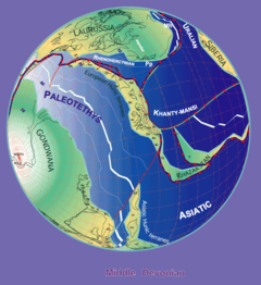
 Paleogeography of the Middle Devonian 380 Ma, by Stampfli & Borel | |
The Floresta Formation (Spanish: Formación Floresta, Df) is a geological formation of the Altiplano Cundiboyacense in the Eastern Ranges of the Colombian Andes. The sequence of siltstones, shales, coquinas and sandstone beds dates to the Devonian period; Late Emsian, Eifelian and Early Givetian epochs, and has a maximum thickness of 600 metres (2,000 ft). The unit is highly fossiliferous; brachiopods, bryozoans, gastropods, trilobites, corals and bivalves have been found in the Floresta Formation. Some fragments of Placoderm fish fossils were found in the Floresta Formation, while the overlying Cuche Formation is much richer in fish biodiversity.