Florida, Massachusetts | |
|---|---|
| Town of Florida | |
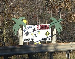
 Welcome sign along the Mohawk Trail | |
|
| |
 Location in Berkshire County and Massachusetts. | |
| Coordinates: 42°40′00″N 73°00′42″W / 42.66667°N 73.01167°W | |
| Country | United States |
| State | Massachusetts |
| County | Berkshire |
| Settled | 1783 |
| Incorporated | 1805 |
| Government | |
| • Type | Open town meeting |
| Area | |
| • Total | 24.6 sq mi (63.7 km2) |
| • Land | 24.4 sq mi (63.1 km2) |
| • Water | 0.2 sq mi (0.6 km2) |
| Elevation | 1,895 ft (578 m) |
| Population (2020) | |
| • Total | 694 |
| • Density | 28/sq mi (11/km2) |
| Time zone | UTC-5 (Eastern) |
| • Summer (DST) | UTC-4 (Eastern) |
| ZIP code | 01247, 01343 |
| Area code | 413 |
| FIPS code | 25-24120 |
| GNIS feature ID | 0619419 |
| Website | townofflorida |
Florida is a town in Berkshire County, Massachusetts, United States. It is part of the Pittsfield, Massachusetts Metropolitan Statistical Area. It is home to the east portal of the Hoosac Tunnel, as well as Whitcomb Summit (elevation 2,172 ft or 662 m), the highest point of the Mohawk Trail. Florida contains the village of Drury. At the 2020 census the town had a total population of 694.[1] Despite the town’s name, Florida is statistically the coldest and snowiest town in Massachusetts.[citation needed]
- ^ "Census - Geography Profile: Florida town, Berkshire County, Massachusetts". United States Census Bureau. Retrieved November 14, 2021.


