Floydada, Texas | |
|---|---|
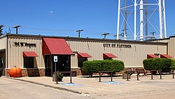
 Floydada City Hall | |
| Nickname(s): Pumpkin Capital of Texas, Pumpkin Capital USA[1] | |
| Coordinates: 33°59′04″N 101°20′16″W / 33.98444°N 101.33778°W[2] | |
| Country | |
| State | |
| County | Floyd |
| Region | Llano Estacado |
| Platted | 1890 |
| Area | |
| • Total | 2.04 sq mi (5.27 km2) |
| • Land | 2.04 sq mi (5.27 km2) |
| • Water | 0.00 sq mi (0.00 km2) |
| Elevation | 3,182 ft (970 m) |
| Population (2020) | |
| • Total | 2,675 |
| • Density | 1,300/sq mi (510/km2) |
| Time zone | UTC−6 (CST) |
| ZIP code | 79235 |
| Area code | 806 |
| FIPS code | 48-26268 |
| Website | www |
Floydada (/flɔɪˈdeɪdə/ floy-DAY-də) is a city in and the county seat of Floyd County, Texas, United States.[5] This rural community lies on the high plains of the Llano Estacado in West Texas and is sometimes referred to as the Pumpkin Capital of Texas.[6] The population was 2,675 at the 2020 census,[7] down from 3,038 at the 2010 census[8] and 3,676 at the 2000 census.
- ^ "Home | Floydada Chamber of Commerce & Agriculture". Floydada Chamber. Retrieved July 31, 2024.
- ^ a b "Floydada". Geographic Names Information System. United States Geological Survey, United States Department of the Interior.
- ^ "2019 U.S. Gazetteer Files". United States Census Bureau. Retrieved August 7, 2020.
- ^ Site inactive as of August 7, 2020
- ^ "Find a County". National Association of Counties. Archived from the original on May 31, 2011. Retrieved June 7, 2011.
- ^ Floydada Chamber of Commerce. "Punkin Days (aka Pumpkin Days)". Welcome to Floydada, Texas. Archived from the original on January 28, 2015. Retrieved January 27, 2015.
- ^ "Explore Census Data". data.census.gov. Retrieved May 24, 2024.
- ^ "Geographic Identifiers: 2010 Demographic Profile Data (G001): Floydada city, Texas". U.S. Census Bureau, American Factfinder. Retrieved August 25, 2016.[dead link]

