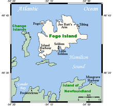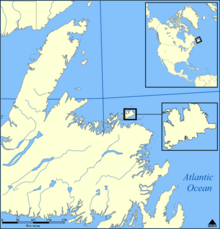


Fogo Island (Fogo, Portuguese for "Fire") is the largest of the offshore islands of Newfoundland and Labrador, Canada. The Town of Fogo Island encompasses Fogo, Joe Batt's Arm-Barr'd Islands-Shoal Bay, Seldom-Little Seldom and Tilting, with the unincorporated areas of Fogo Island.[2] It lies off the northeast coast of Newfoundland, northwest of Musgrave Harbour across Hamilton Sound, just east of the Change Islands. The island is about 25 km (16 mi) long and 14 km (8.7 mi) wide. The total area is 237.71 km2 (91.78 sq mi).
The island had a population of 2,706 people in the 2006 census, 2,395 in the 2011 census, and 2,244 in the 2016 census.[3]
Though migratory French fishermen visited Fogo Island from the early 16th century until 1718, the first permanent settlement of the island took place in the 18th century. Fogo Harbour and Tilting Harbour were the first settlements on the island. The English and Irish descendants of the first inhabitants retained traces of their Elizabethan English and Old Irish dialects, which can be heard on the island today. The island has many ancient folk customs brought from England and Ireland, but they are disappearing.
- ^ Cite error: The named reference
mun.ca-seldomcomebywas invoked but never defined (see the help page). - ^ Cite error: The named reference
amalgamationwas invoked but never defined (see the help page). - ^ "Fogo Island, T [Census subdivision], Newfoundland and Labrador and Newfoundland and Labrador [Province]". 2016 Census. Statistics Canada. Retrieved 29 May 2017.