Foloi
Φολόη | |
|---|---|
| Coordinates: 37°47′N 21°43′E / 37.783°N 21.717°E | |
| Country | Greece |
| Administrative region | West Greece |
| Regional unit | Elis |
| Municipality | Archaia Olympia |
| Area | |
| • Municipal unit | 174.2 km2 (67.3 sq mi) |
| Elevation | 640 m (2,100 ft) |
| Population (2021)[1] | |
| • Municipal unit | 2,293 |
| • Municipal unit density | 13/km2 (34/sq mi) |
| • Community | 156 |
| Time zone | UTC+2 (EET) |
| • Summer (DST) | UTC+3 (EEST) |
| Postal code | 270 66 |
| Area code(s) | 26240 |
| Vehicle registration | ΗΑ |
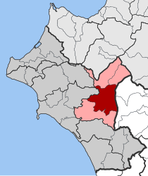
Foloi (Greek: Φολόη, Latin: Pholoe) is a village and a former municipality in Elis, West Greece, Greece. Since the 2011 local government reform it is part of the municipality Archaia Olympia, of which it is a municipal unit.[2] The municipal unit has an area of 174.202 km2.[3] The seat of the municipality was in the village Lalas, in the southern part of the municipal unit. The village Foloi is situated in the northwestern part. Foloi is situated in a mountainous, sparsely populated area. The Foloi oak forest is located in the municipal unit. Foloi is located about 15 km northeast of Olympia, 30 km east of Pyrgos and 55 km south of Patras. It borders on Arcadia to the east, across the river Erymanthus.
- ^ "Αποτελέσματα Απογραφής Πληθυσμού - Κατοικιών 2021, Μόνιμος Πληθυσμός κατά οικισμό" [Results of the 2021 Population - Housing Census, Permanent population by settlement] (in Greek). Hellenic Statistical Authority. 29 March 2024.
- ^ "ΦΕΚ B 1292/2010, Kallikratis reform municipalities" (in Greek). Government Gazette.
- ^ "Population & housing census 2001 (incl. area and average elevation)" (PDF) (in Greek). National Statistical Service of Greece. Archived from the original (PDF) on 2015-09-21.

