Forbestown | |
|---|---|
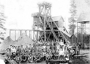
 Shakespeare Mining & Milling Co, headframe and miners, ca. 1860 | |
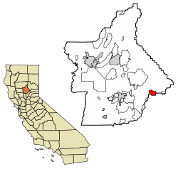
 Location of Forbestown in Butte County, California. | |
| Coordinates: 39°31′02″N 121°16′02″W / 39.51722°N 121.26722°W | |
| Country | |
| State | |
| County | Butte County |
| Area | |
| • Total | 6.280 sq mi (16.265 km2) |
| • Land | 6.274 sq mi (16.250 km2) |
| • Water | 0.006 sq mi (0.015 km2) 0.09% |
| Elevation | 2,772 ft (845 m) |
| Population | |
| • Total | 396 |
| • Density | 63/sq mi (24/km2) |
| Time zone | UTC-8 (Pacific (PST)) |
| • Summer (DST) | UTC-7 (PDT) |
| GNIS feature IDs | 1656023; 2612480 |
| U.S. Geological Survey Geographic Names Information System: Forbestown, California, U.S. Geological Survey Geographic Names Information System: Forbestown, California | |
Forbestown (formerly, Boles Dry Diggins and Forbes Diggins) is a census-designated place[4] in Butte County, California.[2] It lies at an elevation of 2772 feet (845 m).[2] Its zip code is 95941 and its area code is 530. Forbestown had a population of 320 at the 2010 census.
Forbestown is named for B.F. Forbes, who opened a store there in 1850.[5] The post office was established in 1854, closed in 1925, and re-opened in 1936.[5]
Forbestown's heyday was the last half of the nineteenth century, when it was a large mining center.[6] By the late 1930s, it was nearly a ghost town.[6] The site has foundations and debris from its mining era.[6]
- ^ "2010 Census U.S. Gazetteer Files – Places – California". United States Census Bureau.
- ^ a b c U.S. Geological Survey Geographic Names Information System: Forbestown, California
- ^ "Explore Census Data". data.census.gov. Retrieved June 29, 2023.
- ^ U.S. Geological Survey Geographic Names Information System: Forbestown, California
- ^ a b Durham, David L. (1998). California's Geographic Names: A Gazetteer of Historic and Modern Names of the State. Clovis, Calif.: Word Dancer Press. p. 236. ISBN 1-884995-14-4.
- ^ a b c Miller, Donald C. (1978). Ghost Towns of California. Boulder, Colorado: Pruett Publishing Company. p. 65. ISBN 0871085178.
