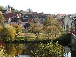
Forchtenberg | |
|---|---|
 | |
Location of Forchtenberg within Hohenlohekreis district  | |
| Coordinates: 49°17′N 9°34′E / 49.283°N 9.567°E | |
| Country | Germany |
| State | Baden-Württemberg |
| Admin. region | Stuttgart |
| District | Hohenlohekreis |
| Municipal assoc. | Mittleres Kochertal |
| Subdivisions | 5 |
| Government | |
| • Mayor (2024–32) | Michael Foss[1] (CDU) |
| Area | |
| • Total | 38.07 km2 (14.70 sq mi) |
| Elevation | 223 m (732 ft) |
| Population (2022-12-31)[2] | |
| • Total | 5,285 |
| • Density | 140/km2 (360/sq mi) |
| Time zone | UTC+01:00 (CET) |
| • Summer (DST) | UTC+02:00 (CEST) |
| Postal codes | 74670 |
| Dialling codes | 07947 |
| Vehicle registration | KÜN |
| Website | www.forchtenberg.de |
Forchtenberg is a town in the district of Hohenlohekreis, northern Baden-Württemberg. It lies on the side of a partly fortified hill overlooking the Kocher valley where the Kupfer river flows into the Kocher. The name Forchtenberg is derived from "vor dem Berg" or "before the hill" in English.
- ^ Bürgermeisterwahl Forchtenberg 2024, Staatsanzeiger. Retrieved 12 June 2024.
- ^ "Bevölkerung nach Nationalität und Geschlecht am 31. Dezember 2022" [Population by nationality and sex as of December 31, 2022] (CSV) (in German). Statistisches Landesamt Baden-Württemberg. June 2023.


