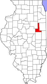
Ford County | |
|---|---|
 Ford County Courthouse in Paxton | |
 Location within the U.S. state of Illinois | |
 Illinois's location within the U.S. | |
| Coordinates: 40°35′N 88°13′W / 40.59°N 88.22°W | |
| Country | |
| State | |
| Founded | February 17, 1859 |
| Named for | Thomas Ford |
| Seat | Paxton |
| Largest city | Paxton |
| Area | |
| • Total | 486 sq mi (1,260 km2) |
| • Land | 486 sq mi (1,260 km2) |
| • Water | 0.6 sq mi (2 km2) 0.1% |
| Population (2020) | |
| • Total | 13,534 |
| • Estimate (2023) | 13,250
|
| • Density | 28/sq mi (11/km2) |
| Time zone | UTC−6 (Central) |
| • Summer (DST) | UTC−5 (CDT) |
| Congressional districts | 2nd, 16th |
| Website | www |
Ford County is a county located in the U.S. state of Illinois. According to the 2020 United States Census, it had a population of 13,534.[1] Its county seat is Paxton.[2] Ford County was part of the Champaign–Urbana, IL Metropolitan Statistical Area until 2018, when the Office of Management and Budget removed the county from the area.[3][4]
- ^ "Ford County, Illinois". United States Census Bureau. Retrieved June 8, 2023.
- ^ "Find a County". National Association of Counties. Archived from the original on May 3, 2015. Retrieved June 7, 2011.
- ^ Office of Management and Budget (April 10, 2018). "OMB Bulletin No. 18-03: Revised Delineations of Metropolitan Statistical Areas, Micropolitan Statistical Areas, and Combined Statistical Areas, and Guidance on Uses of the Delineations of These Areas" (PDF). Archived (PDF) from the original on April 11, 2018. Retrieved December 27, 2021.
- ^ Office of Management and Budget (September 14, 2018). "OMB Bulletin No. 18-04: Revised Delineations of Metropolitan Statistical Areas, Micropolitan Statistical Areas, and Combined Statistical Areas, and Guidance on Uses of the Delineations of These Areas" (PDF). Archived (PDF) from the original on September 15, 2018. Retrieved December 27, 2021.