Forest City, North Carolina | |
|---|---|
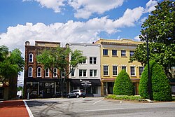
 Main Street | |
 Location of Forest City, North Carolina | |
| Coordinates: 35°20′02″N 81°52′13″W / 35.33389°N 81.87028°W | |
| Country | United States |
| State | North Carolina |
| County | Rutherford |
| Area | |
| • Total | 8.59 sq mi (22.23 km2) |
| • Land | 8.57 sq mi (22.19 km2) |
| • Water | 0.02 sq mi (0.04 km2) |
| Elevation | 1,011 ft (308 m) |
| Population (2020) | |
| • Total | 7,377 |
| • Density | 860.89/sq mi (332.40/km2) |
| Time zone | UTC-5 (Eastern (EST)) |
| • Summer (DST) | UTC-4 (EDT) |
| ZIP code | 28043 |
| Area code | 828 |
| FIPS code | 37-24080[3] |
| GNIS feature ID | 2406505[2] |
| Website | www |
Forest City, formerly known as "Burnt Chimney,"[4] is a town in Rutherford County, North Carolina, United States. The population was 7,377 as of the 2020 census, making it the most populous municipality in Rutherford County.
- ^ "ArcGIS REST Services Directory". United States Census Bureau. Retrieved September 20, 2022.
- ^ a b U.S. Geological Survey Geographic Names Information System: Forest City, North Carolina
- ^ "U.S. Census website". United States Census Bureau. Retrieved January 31, 2008.
- ^ "History and Facts". Town of Forest City. Archived from the original on May 12, 2012. Retrieved December 7, 2012.
