Forestville | |
|---|---|
 | |
| Motto: Per sylvam ("Through the forest") | |
 Location within La Haute-Côte-Nord RCM | |
| Coordinates: 48°44′N 69°05′W / 48.733°N 69.083°W[1] | |
| Country | Canada |
| Province | Quebec |
| Region | Côte-Nord |
| RCM | La Haute-Côte-Nord |
| Settled | 1844 |
| Constituted | January 5, 1980 |
| Government | |
| • Mayor | Micheline Anctil |
| • Federal riding | Beauport—Côte-de-Beaupré—Île d'Orléans—Charlevoix |
| • Prov. riding | René-Lévesque |
| Area | |
| • Total | 244.42 km2 (94.37 sq mi) |
| • Land | 192.61 km2 (74.37 sq mi) |
| Population (2021)[3] | |
| • Total | 2,892 |
| • Density | 15.0/km2 (39/sq mi) |
| • Pop (2016-21) | |
| • Dwellings | 1,577 |
| Time zone | UTC−5 (EST) |
| • Summer (DST) | UTC−4 (EDT) |
| Postal code(s) | |
| Area code(s) | 418 and 581 |
| Highways | |
| Website | ville |
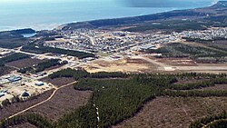
Forestville is a town in the Côte-Nord region of Quebec, Canada. It is located on the north shore of the St. Lawrence River along Route 138, approximately 103 kilometres (64 mi) southwest of Baie-Comeau. There is a vehicle and passenger ferry service from Forestville to Rimouski, on the south shore of the St. Lawrence that is over 50 kilometres (31 mi) wide at this point.[4] The city operates the Forestville Airport.
Forestville is known for its hunting and fishing. Mooose hunting season is popular. There are many lakes and rivers to fish, as well as beaches and camping spots for the summer, and cross country skiing in the winter. It hosts the Boreal Loppet, a cross-country skiing race with varying distances including 60 kilometres (37 mi). It also hosted the longest cross-country ski race in the world, at 103 kilometres (64 mi), from 2005 to 2011.
- ^ Cite error: The named reference
toponymiewas invoked but never defined (see the help page). - ^ a b "Répertoire des municipalités: Geographic code 95045". www.mamh.gouv.qc.ca (in French). Ministère des Affaires municipales et de l'Habitation. Retrieved 2024-06-25.
- ^ a b "Forestville, Quebec (Code 2495045) Census Profile". 2021 census. Government of Canada - Statistics Canada. Retrieved 2024-06-25.
- ^ "Bonjour Québec.com: Rimouski/Forestville crossing". Archived from the original on 2007-09-26. Retrieved 2007-08-01.
