| Forestville Mystery Cave State Park | |
|---|---|
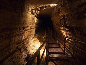
 A passage in Mystery Cave | |
| Location | Fillmore, Minnesota, United States |
| Coordinates | 43°38′23″N 92°12′43″W / 43.63972°N 92.21194°W |
| Area | 3,170 acres (12.8 km2) |
| Elevation | 1,266 ft (386 m)[1] |
| Established | 1941 |
| Governing body | Minnesota Department of Natural Resources |
Forestville Townsite--Meighan Store | |
 Historic bridge to Forestville | |
| Coordinates | 43°38′34″N 92°12′53″W / 43.642680°N 92.214855°W |
|---|---|
| Architect | Robert Foster; Felix Meighen |
| NRHP reference No. | 73000976 |
| Added to NRHP | April 13, 1973 |
Forestville Mystery Cave State Park is a state park in Minnesota. It contains the village of Forestville, which has been restored to a 19th-century appearance. The Minnesota Historical Society operates it as a historic site. Below ground the park contains Mystery Cave, the state's longest cave, which is open to the public. The park is between Spring Valley and Preston, Minnesota.
- ^ "Forestville State Park". Geographic Names Information System. United States Geological Survey. October 4, 2004. Retrieved February 24, 2011.


