| Forillon National Park | |
|---|---|
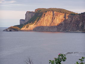
 Cap Bon-Ami at sunset | |
| Location | Gaspésie–Îles-de-la-Madeleine, La Côte-de-Gaspé Regional County Municipality, Quebec, Canada |
| Nearest city | Gaspé, Quebec |
| Coordinates | 48°54′N 64°21′W / 48.900°N 64.350°W |
| Area | 244 km2 (94 sq mi) |
| Established | 8 June 1970 |
| Visitors | 164,130 (in 2022–23[1]) |
| Governing body | Parks Canada |
Forillon National Park, one of 42 national parks and park reserves across Canada, is located at the outer tip of the Gaspé Peninsula of Quebec and covers 244 km2 (94 sq mi).[2]
Created in 1970, Forillon was the first national park in Quebec. The park includes forests, sea coast, salt marshes, sand dunes, cliffs, and the Eastern End of the Appalachians. The word forillon is thought to have referred to a flowerpot island or sea stack which used to be a landmark in the area but has since collapsed into the ocean.
- ^ Canada, Parks. "Parks Canada attendance 2022_23 - Parks Canada attendance 2022_23 - Open Government Portal". open.canada.ca. Retrieved 2024-05-07.
- ^ Parks Canada Agency, Government of Canada (4 December 2017). "Forillon National Park". www.pc.gc.ca.

