Formoso | |
|---|---|
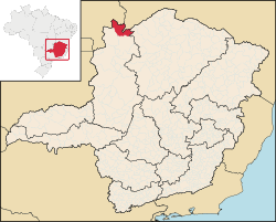
 Location of Formoso in the state of Minas Gerais | |
| Coordinates: 14°57′08″S 46°13′54″W / 14.95222°S 46.23167°W | |
| Country | Brazil |
| State | Minas Gerais |
| Government | |
| • Mayor | Luís Carlos da Silva (2005–09) |
| Area | |
• Total | 3,699 km2 (1,428 sq mi) |
| Elevation | 839 m (2,753 ft) |
| Population (2020)[1] | |
• Total | 9,688 |
| • Density | 2.6/km2 (6.8/sq mi) |
| Time zone | UTC−3 (BRT) |
Formoso is a municipality in northern Minas Gerais state, Brazil. It is located northeast of Brasília, in a pocket where the boundaries of the states of Minas Gerais, Goiás, and Bahia come together.
Formoso is part of the statistical micro-region of Unaí, which consists of the municipalities of Arinos, Bonfinópolis de Minas, Buritis, Cabeceira Grande, Dom Bosco, Formoso, Natalândia, Unaí, and Uruana de Minas. The population of this micro-region was 133,168 (2000) in a total area of 27,653 km2. The population density of the region is very low, 4.82 inhabitants/km2 in 2000.
There are highway connections, MG-400 then GO-108 with Sítio d'Abadia, 14 kilometers to the north in Goiás. From Sítio there are unpaved (2001) highway connections (GO-112) with Alvorada do Norte on the BR-020 highway (Salvador-Brasília), a distance of 69 kilometers.
Formoso is north of the Grande Sertão Veredas National Park, created in 1989. This park is a natural area protecting the flora and fauna of the cerrado, but not open to the public.Ambiente Brasil