Forsand Municipality
Forsand kommune | |
|---|---|
| Fossan herred (historic name) | |
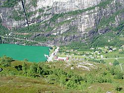
 Lysebotn, located at the head of the Lysefjorden | |
|
| |
 Rogaland within Norway | |
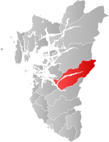
 Forsand within Rogaland | |
| Coordinates: 59°00′49″N 06°25′28″E / 59.01361°N 6.42444°E | |
| Country | Norway |
| County | Rogaland |
| District | Ryfylke |
| Established | 1 Jan 1871 |
| • Preceded by | Høgsfjord Municipality |
| Disestablished | 1 Jan 2020 |
| • Succeeded by | Sandnes and Strand municipalities |
| Administrative centre | Forsand |
| Government | |
| • Mayor (2015-2019) | Bjarte Sveinsvoll Dagestad (H) |
| Area (upon dissolution) | |
• Total | 780.06 km2 (301.18 sq mi) |
| • Land | 698.83 km2 (269.82 sq mi) |
| • Water | 81.23 km2 (31.36 sq mi) |
| • Rank | #141 in Norway |
| Population (2017) | |
• Total | 1,245 |
| • Rank | #376 in Norway |
| • Density | 1.8/km2 (5/sq mi) |
| • Change (10 years) | |
| Demonym | Forsandbu[1] |
| Official language | |
| • Norwegian form | Nynorsk |
| Time zone | UTC+01:00 (CET) |
| • Summer (DST) | UTC+02:00 (CEST) |
| ISO 3166 code | NO-1129[3] |
| Website | Official website |
Forsand is a former municipality in Rogaland county, Norway. The 780-square-kilometre (300 sq mi) municipality existed from 1871 until 2020 when it was merged into Sandnes municipality. It was located in the traditional district of Ryfylke. The administrative centre of the municipality was the village of Forsand. Other villages in the municipality included Lysebotn, Øvre Espedal, Oanes, Kolabygda, and Fløyrli.
Forsand municipality surrounded the famous Lysefjorden and it was located on the east side of the Høgsfjorden. In 1999, evidence of a population here dating back to around 7500 BC was located.
Prior to its dissolution in 2020, it was one of the largest municipalities within the county of Rogaland in terms of area, and one of the smallest in terms of population. The 780-square-kilometre (300 sq mi) municipality was the 141st largest by area out of the 422 municipalities in Norway. Forsand was the 376th most populous municipality in Norway with a population of 1,245. The municipality's population density was 1.8 inhabitants per square kilometre (4.7/sq mi) and its population has increased by 12.9% over the last decade.[4]
- ^ "Navn på steder og personer: Innbyggjarnamn" (in Norwegian). Språkrådet.
- ^ "Forskrift om målvedtak i kommunar og fylkeskommunar" (in Norwegian). Lovdata.no.
- ^ Bolstad, Erik; Thorsnæs, Geir, eds. (26 January 2023). "Kommunenummer". Store norske leksikon (in Norwegian). Kunnskapsforlaget.
- ^ Statistisk sentralbyrå (2017). "Table: 06913: Population 1 January and population changes during the calendar year (M)" (in Norwegian). Retrieved 4 November 2017.

