Fort Chipewyan | |
|---|---|
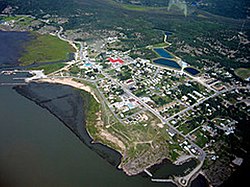
 Aerial view of Fort Chipewyan | |
| Coordinates: 58°42′52″N 111°09′30″W / 58.71444°N 111.15833°W | |
| Country | Canada |
| Province | Alberta |
| Region | Northern Alberta |
| Census division | 16 |
| Specialized municipality | RM of Wood Buffalo |
| Settled | 1788[1] |
| Government | |
| • Type | Unincorporated |
| • Mayor | Sandy Bowman |
| • Governing body | Wood Buffalo Municipal Council
|
| Area (2021)[2] | |
| • Land | 9.93 km2 (3.83 sq mi) |
| Elevation | 221 m (725 ft) |
| Population (2021)[2] | |
• Total | 798 |
| • Density | 80.4/km2 (208/sq mi) |
| Time zone | UTC−7 (MST) |
| • Summer (DST) | UTC−6 (MDT) |
| Postal code | |
| Area code | +1-780 |
| Climate | Dfc |
Fort Chipewyan /ˈtʃɪpəwaɪən, -pwaɪ-, ˈtʃɪpəwən/, commonly referred to as Fort Chip, is a hamlet in northern Alberta, Canada, within the Regional Municipality (RM) of Wood Buffalo.[4] It is located on the western tip of Lake Athabasca, adjacent to Wood Buffalo National Park, approximately 223 kilometres (139 mi) north of Fort McMurray.
- ^ Athabasca Tribal Council – Athabasca Chipewyan First Nation Archived 2009-02-23 at the Wayback Machine
- ^ a b Cite error: The named reference
2021censuswas invoked but never defined (see the help page). - ^ "Alberta Private Sewage Systems 2009 Standard of Practice Handbook: Appendix A.3 Alberta Design Data (A.3.A. Alberta Climate Design Data by Town)" (PDF) (PDF). Safety Codes Council. January 2012. pp. 212–215 (PDF pp. 226–229). Archived from the original (PDF) on October 16, 2013. Retrieved October 8, 2013.
- ^ "Specialized and Rural Municipalities and Their Communities" (PDF). Alberta Municipal Affairs. June 3, 2024. Retrieved June 14, 2024.
