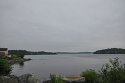
"The Rim" and Site of Fort Foster | |
 View toward The Rim from the south | |
| Nearest city | East Machias, Maine |
|---|---|
| Coordinates | 44°43′1″N 67°23′45″W / 44.71694°N 67.39583°W |
| Area | 200 acres (81 ha) |
| Built | 1775 |
| NRHP reference No. | 73000155[1] |
| Added to NRHP | July 23, 1973 |
Fort Foster was a military site of the American Revolutionary War in what is now East Machias, Maine. Little more than a large earthworks, it was located on The Rim, a neck of land that commands the confluence of the Machias and East Machias Rivers. The earthworks were built in 1776, and attacked by British forces in the 1777 Battle of Machias. The site was listed on the National Register of Historic Places in 1973.[1]

