| Fort Funston | |
|---|---|
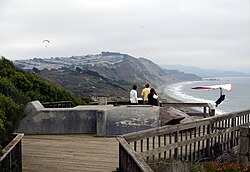
 A hang glider launches from Fort Funston Overlook, San Francisco. The launch platform is modified from a former fire control bunker. | |
| Location | San Francisco, California, United States |
| Coordinates | 37°42′54″N 122°30′07″W / 37.714958°N 122.501915°W |
| Operated by | Golden Gate National Parks Conservancy |
| Website | Official website |
| Fort Funston | |
Lake Merced Military Reservation | |
| Near San Francisco, California in United States | |
| Type | Harbor defense installation |
| Site information | |
| Owner | United States Army |
| Controlled by | United States Army Coast Artillery Corps |
| Site history | |
| Built | 1900 |
| Fate | Decommission 1963 |


Fort Funston is a former harbor defense installation located in the southwestern corner of San Francisco. Formerly known as the Lake Merced Military Reservation, the fort is now a protected area within the Golden Gate National Recreation Area (GGNRA) and is used widely as an off-leash dog park. It was named in honor of Frederick N. Funston (1865–1917), a Major General in the United States Army with strong connections to San Francisco, and included several artillery batteries. The fort is located on Skyline Boulevard at John Muir Drive, west of Lake Merced.
The fort was constructed upon windswept headlands along the Pacific coast and Ocean Beach below, above steep sandstone cliffs that provide a nesting habitat for a colony of bank swallows (Riparia riparia). The last remnants of a sand dune ecosystem that once covered the western half of San Francisco grow along the top of the headlands, with trailheads forming part of the California Coastal Trail that runs through San Francisco County.[1]
- ^ The Coastal Trail is temporarily closed due to erosion.


