Fort Garland, Colorado | |
|---|---|
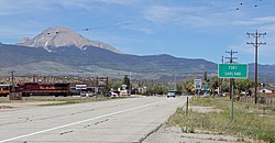
 Fort Garland from the south. | |
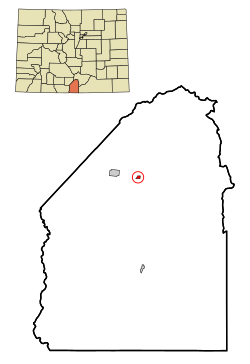
 Location of the Fort Garland CDP in Costilla County, Colorado. | |
Location of the Fort Garland CDP in the United States. | |
| Coordinates: 37°25′41″N 105°26′06″W / 37.42806°N 105.43500°W[1] | |
| Country | |
| State | |
| County | Costilla County |
| Established | 1858 |
| Government | |
| • Type | unincorporated town |
| Area | |
| • Total | 0.376 sq mi (0.973 km2) |
| • Land | 0.376 sq mi (0.973 km2) |
| • Water | 0 sq mi (0 km2) |
| Elevation | 7,937 ft (2,419 m) |
| Population | |
| • Total | 464 |
| • Density | 1,200/sq mi (480/km2) |
| Time zone | UTC-7 (MST) |
| • Summer (DST) | UTC-6 (MDT) |
| ZIP code[4] | 81133 |
| Area code | 719 |
| GNIS feature | 2408238[1] |
Fort Garland is an unincorporated town, a post office, and a census-designated place (CDP) located in and governed by Costilla County, Colorado, United States. The Fort Garland post office has the ZIP Code 81133.[4] At the United States Census 2020, the population of the Fort Garland CDP was 464.[3]
- ^ a b c d U.S. Geological Survey Geographic Names Information System: Fort Garland, Colorado
- ^ "State of Colorado Census Designated Places - BAS20 - Data as of January 1, 2020". United States Census Bureau. Retrieved December 21, 2020.
- ^ a b United States Census Bureau. "Fort Garland CDP, Colorado". Retrieved April 2, 2023.
- ^ a b "Look Up a ZIP Code". United States Postal Service. Retrieved November 21, 2020.
