 | |
 | |
| Location | Omar and Garfield Sts., Port Huron, Michigan |
|---|---|
| Coordinates | 43°0′22.7″N 82°25′20.9″W / 43.006306°N 82.422472°W |
| Tower | |
| Constructed | 1825 |
| Foundation | Dressed stone and timber[4] |
| Construction | Brick |
| Automated | 1933 |
| Height | 85 feet (26 m)[1] |
| Shape | Frustum of a cone attached to workroom[5] |
| Markings | White |
| Heritage | National Register of Historic Places listed place, Michigan state historic site |
| Fog signal | Station will give available information on fog conditions in upper river by radiotelephone when requested, (156.80 MHz). Standby light of reduced intensity lighted throughout 24 hours.[6] |
| Light | |
| First lit | 1825 |
| Focal height | 82 feet (25 m)[2] |
| Lens | Fourth-order Fresnel lens (original), DCB-224 Carlisle & Finch Aerobeacon (current) |
| Range | 18 nautical miles (33 km; 21 mi) |
| Characteristic | Fl green 6 seconds[3] |
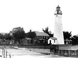
Fort Gratiot Lighthouse | |
 Undated USCG image | |
| Area | less than one acre |
| Architect | Lyon, Lucius; Moors, J. |
| NRHP reference No. | 76001975[7] |
| Added to NRHP | July 30, 1976 |
Fort Gratiot Light /ˈɡræʃɪt/, the first lighthouse in the state of Michigan, was constructed north of Fort Gratiot in 1825 by Lucius Lyon, who later became one of Michigan's first U.S. Senators.[8]
The Fort Gratiot Light marks the entrance to the St. Clair River from Lake Huron (going south) in the southern portion of Michigan's Thumb. The light is still active and the grounds are an active Coast Guard facility, but it has recently been handed over to the Port Huron Museum. It is the oldest surviving lighthouse in Michigan. There is also a public beach and park on the property, known as Lighthouse Beach.
It is across the river from Point Edward Front Range Light.[9]
- ^ Pepper, Terry. "Database of Tower Heights". Seeing the Light. terrypepper.com. Archived from the original on 2000-09-18.
- ^ Pepper, Terry. "Database of Focal Heights". Seeing the Light. terrypepper.com. Archived from the original on 2008-08-30.
- ^ Light List, Volume VII, Great Lakes (PDF). Light List. United States Coast Guard.
- ^ Michigan Lighthouse fund, Fort Gratiot light. Archived 2011-07-27 at the Wayback Machine
- ^ "Historic Light Station Information and Photography: Michigan". United States Coast Guard Historian's Office. Archived from the original on 2017-05-01.
- ^ Map of Michigan Lighthouse Archived 2008-01-14 at the Wayback Machine in PDF Format.
- ^ "National Register Information System". National Register of Historic Places. National Park Service. March 13, 2009.
- ^ "Fort Gratiot lighthouse". Archived from the original on 2011-03-19.
- ^ Interactive map, list, information for lighthouses in North and West Lake Huron. Archived April 25, 2008, at the Wayback Machine