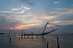
Fort Kochi
Cochim de Baixo | |
|---|---|
 | |
| Coordinates: 9°57′40″N 76°14′35″E / 9.961°N 76.243°E | |
| Country | India |
| State | Kerala |
| District | Ernakulam |
| Population | |
• Total | 234,990 |
| Languages | |
| • Official | Malayalam, English |
| Time zone | UTC+5:30 (IST) |
| PIN | 682001 |
| Telephone code | 0484 |
| Vehicle registration | KL-43 |

Fort Kochi (/ˈkoʊtʃi/ KOH-chee, Malayalam: [foːrʈ kotˈt͡ʃi]; Cochin Portuguese Creole: Cochim de Baixo, European Portuguese: [kuˈʃĩ ðɨ ˈβaʃu]), formerly known as Fort Cochin or British Cochin,[1] is a neighbourhood of Kochi city in Kerala, India. Fort Kochi takes its name from the Fort Manuel of Kochi,[2] the first European fort on Indian soil, controlled by the Portuguese East Indies.[3] This is part of a handful of water-bound islands and islets toward the south-west of the mainland Kochi, and collectively known as Old Kochi or West Kochi. Adjacent to this is the locality of Mattancherry. In 1967, these three municipalities along with a few adjoining areas, were amalgamated to form the Kochi Municipal Corporation.
Fort Kochi is rich in heritage and culture, and is a prominent tourist destination for both domestic and international travellers- being ranked as ninth among the top 25 in National Geographic’s Top Tourist Destinations To Explore In 2020.[4]
- ^ Service, Express News (5 January 2016). "It's 127 Years Since 'Chandrabhanu' Gutted 'Cochi'". The New Indian Express. Retrieved 17 June 2024.
- ^ "About Fort Cochin | Vasco House Fort Cochin | Homestay Fort Cochin | Heritage House". Archived from the original on 12 December 2019.
- ^ "THE MELTING POT OF CULTURES". Kimansion. Retrieved 25 June 2016.
- ^ "Here's where you should book a trip in 2020". Good Morning America.


