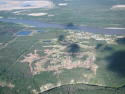
Fort McKay
Fort MacKay | |
|---|---|
 Aerial view of Fort McKay | |
| Coordinates: 57°10′52″N 111°35′59″W / 57.18111°N 111.59972°W | |
| Country | Canada |
| Province | Alberta |
| Census division | No. 16 |
| Specialized municipality | RM of Wood Buffalo |
| Established | 1820[1] |
| Named | 1912[1] |
| Government | |
| • Mayor | Sandy Bowman |
| • Governing body | Wood Buffalo Municipal Council
|
| Area | |
| • Total | 9.53 km2 (3.68 sq mi) |
| Elevation | 260 m (850 ft) |
| Population | |
| • Total | 742 |
| • Density | 77.9/km2 (202/sq mi) |
| Time zone | UTC-7 (MST) |
| • Summer (DST) | UTC-6 (MDT) |
| Postal code span | |
| Area code(s) | 780, 587, 825 |
| Highways | Highway 63 |
| Waterways | Athabasca River |
| Website | RM of Wood Buffalo |
Fort McKay (/məˈkaɪ/ mə-KY)[3] or Fort MacKay is a community in northeast Alberta, Canada, located at the confluence of the Athabasca and MacKay rivers. It is approximately 54 km (34 mi) north of Fort McMurray via Highway 63 and Fort McKay Road. The community has an elevation of 260 m (850 ft).
The majority of the community is an Indian settlement of the Fort McKay First Nation (FMFN). The smaller portion of the community, known as Fort MacKay before 2018, is located adjacent to the FMFN lands to the south within the Regional Municipality (RM) of Wood Buffalo. The portion of the community within the RM of Wood Buffalo is designated as a hamlet.[4][5][6]
- ^ a b "1820 to Present Discovery and Growth". Fort McKay - About us. Fort McKay First Nation. Retrieved May 7, 2016.
- ^ a b Cite error: The named reference
2016censusABmuniswas invoked but never defined (see the help page). - ^ Condon, Olivia (January 23, 2018). "F'Spirit of reconciliation' at council's Fort McKay meeting". Postmedia Network. Fort McMurray Today. Retrieved February 7, 2018.
- ^ "Specialized and Rural Municipalities and Their Communities" (PDF). Alberta Municipal Affairs. June 3, 2024. Retrieved June 14, 2024.
- ^ "Fort MacKay". Regional Municipality of Wood Buffalo. Archived from the original on December 24, 2013. Retrieved May 13, 2011.
- ^ "About Fort McKay". Fort McKay First Nation. Retrieved May 13, 2011.
