| Fort Mifflin | |
|---|---|
| Philadelphia, Pennsylvania, U.S. in United States | |
 | |
| Site information | |
| Owner | City of Philadelphia |
| Operator | United States Army Corps of Engineers |
| Open to the public | yes |
| Site history | |
| Built | 1771 - 1776 |
| Battles/wars | Siege of Fort Mifflin |
Fort Mifflin | |
| Location | Fort Mifflin Road Philadelphia, Pennsylvania, U.S. |
| Coordinates | 39°52′31″N 75°12′47″W / 39.8753°N 75.213°W |
| Architect | John Montresor Pierre Charles L'Enfant Louis de Tousard |
| NRHP reference No. | 70000554[1] |
| Significant dates | |
| Added to NRHP | August 29, 1970 |
| Designated NHL | August 29, 1970 |
| Designated PHMC | May 10, 1990[2] |
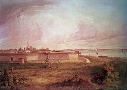
Fort Mifflin, originally called Fort Island Battery and also known as Mud Island Fort, was commissioned in 1771 and sits on Mud Island (or Deep Water Island) on the Delaware River below Philadelphia, Pennsylvania[nb 1] near Philadelphia International Airport.
During the American Revolutionary War, the British Army bombarded and captured the fort as part of their conquest of Philadelphia in autumn 1777. In 1795, the fort was renamed for Thomas Mifflin, a Continental Army officer and the first post-independence Pennsylvania governor.[3]
The U.S. Army began rebuilding the fort in 1794, and continued to garrison and build on the site into the 19th century. Fort Mifflin housed prisoners during the American Civil War. The U.S. Army decommissioned Fort Mifflin for active duty infantry and artillery in 1962.
While the older portion of the fort was returned to the City of Philadelphia, a portion of the fort's grounds are still actively used by the U.S. Army Corps of Engineers, making it the oldest fort in use by the U.S. military. Historic preservationists have restored the fort, which has been named a National Historic Landmark.
- ^ "National Register Information System". National Register of Historic Places. National Park Service. July 9, 2010.
- ^ "PHMC Historical Markers". Historical Marker Database. Pennsylvania Historical & Museum Commission. Archived from the original on December 7, 2013. Retrieved December 10, 2013.
- ^ Roberts 1988, pp. 686–687.
Cite error: There are <ref group=nb> tags on this page, but the references will not show without a {{reflist|group=nb}} template (see the help page).


