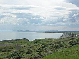
| Fort Peck Lake | |
|---|---|
 The lake seen from the Lewis and Clark Overlook east of the dam | |
| Location | |
| Coordinates | 47°46′41″N 106°40′53″W / 47.77806°N 106.68139°W[1] |
| Lake type | Reservoir |
| Primary inflows | Missouri River, Musselshell River, Fourchette Creek, Dry Creek |
| Primary outflows | Missouri River |
| Catchment area | 57,500 sq mi (149,000 km2)[2] |
| Max. length | 134 mi (216 km)[2] |
| Surface area | 245,000 acres (99,000 ha) |
| Average depth | 76.3 ft (23.3 m) |
| Max. depth | 220 ft (67 m)[2] |
| Water volume | 18,687,731 acre⋅ft (23.050977 km3)[2] |
| Surface elevation | 2,250 feet (690 m)[2] |
| Frozen | Winter |
| Islands | York Island, others unnamed |
| Settlements | Fort Peck |
Fort Peck Lake, or Lake Fort Peck, is a major reservoir in Montana, formed by the Fort Peck Dam on the Missouri River. The lake lies in the eastern prairie region of Montana approximately 140 miles (230 km) east of Great Falls and 120 miles (190 km) north of Billings, reaching into portions of six counties.[1]
The dam and reservoir were built in the 1930s to enhance navigation on the Missouri River, supplying enough water downstream of the dam to provide for a 9-foot deep (2.7 m), 300-foot wide (91 m) navigation channel from Sioux City, Iowa, to the mouth of the Missouri just above St. Louis.[3]
- ^ a b "Fort Peck Lake". Geographic Names Information System. United States Geological Survey, United States Department of the Interior. April 4, 1980. Retrieved July 10, 2011.
- ^ a b c d e "Fort Peck Dam and Reservoir Fact Sheet" (PDF). Omaha District. U.S. Army Corps of Engineers. Archived from the original (PDF) on February 16, 2010. Retrieved July 11, 2011.
- ^ Affairs, United States Congress Senate Committee on Interior and Insular (1960). Upper Missouri Basin Water Rights: Memorandum of the Chairman. May 1960. U.S. Government Printing Office. p. 3.

