| Fort Pierce Inlet State Park | |
|---|---|
IUCN category IV (habitat/species management area) | |
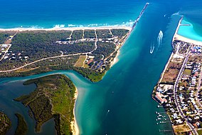
 Aerial view of the inlet | |
| Location | North Hutchinson Island, St. Lucie County, Florida, USA |
| Nearest city | Fort Pierce, Florida |
| Coordinates | 27°28′59″N 80°18′22″W / 27.48306°N 80.30611°W |
| Area | 340 acres (1.4 km2) |
| Governing body | Florida Department of Environmental Protection |
Fort Pierce Inlet State Park, a 340-acre (1.4 km2) part of the Florida State Park system, is located just north of the Fort Pierce Inlet, on North Hutchinson Island, near Fort Pierce. It consists of beaches, dunes and a coastal hammock between the Atlantic Ocean and the waters of Tucker Cove, an indentation of the Indian River Lagoon.[1]
- ^ Map of Fort Pierce, etc, 1998, Fort Lauderdale: Dolph Map Co.

