Fort Pitt Bridge | |
|---|---|
 | |
| Coordinates | 40°26′20″N 80°00′40″W / 40.43883°N 80.01113°W |
| Carries | 8 lanes (4 upper, 4 lower) of |
| Crosses | Monongahela River |
| Locale | Pittsburgh, Pennsylvania |
| Official name | Fort Pitt Bridge |
| Other name(s) | Parkway West #1 |
| Maintained by | PennDOT |
| Characteristics | |
| Design | Double-decked Steel Bowstring Arch bridge |
| Total length | 1,207 feet (368 m) |
| Height | 479 feet (146 m) |
| Longest span | 750 feet (230 m) |
| Clearance below | 47.1 feet (14.4 m) |
| History | |
| Construction cost | $6,305,000[citation needed] |
| Opened | June 19, 1959 |
| Replaces | Point Bridge |
| Statistics | |
| Daily traffic | 150,000[1]: 00:01:21 |
| Location | |
 | |
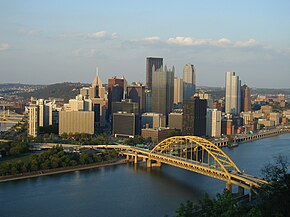
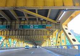
The Fort Pitt Bridge is a steel, double-decked bowstring arch bridge that spans the Monongahela River near its confluence with the Allegheny River in Pittsburgh, Pennsylvania. It carries Interstate 376 between the Fort Pitt Tunnel and Downtown Pittsburgh. Opened in June 1959 as a replacement for the Point Bridge, the Fort Pitt Bridge was the world's first computer-designed bowstring arch bridge[1]: 00:02:43 and double-decked bowstring arch bridge.[2] The bridge is known for its difficult lane changes, especially on the lower level, often requiring people to go from the extreme left lane across two lanes to the extreme right lane in only 700 feet.[3] The upper level is more forgiving for some routes but still requires a full span lane change in 700 feet to get from the south side entrance to the downtown exits.

|

|
- ^ a b Cite error: The named reference
TravelChannel1was invoked but never defined (see the help page). - ^ "The Pittsburgh Press - Google News Archive Search". News.google.com. Retrieved 19 July 2022.
- ^ "Fort Pitt Bridge Internet meme goes viral". www.youtube.com. Retrieved 7 January 2024.