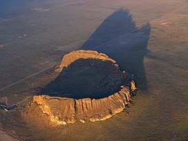
| Fort Rock | |
|---|---|
 Aerial view of Fort Rock from the northeast. | |
| Highest point | |
| Elevation | 4,699 ft (1,432 m) NAVD 88[1] |
| Prominence | 345 ft (105 m) |
| Coordinates | 43°22′20″N 121°04′26″W / 43.372094181°N 121.074011483°W[1] |
| Geography | |
 | |
| Location | Lake County, Oregon, U.S. |
| Parent range | Basin and Range |
| Geology | |
| Rock age | 50,000 to 100,000 years[2] |
| Mountain type | Tuff ring[2] |
| Climbing | |
| Easiest route | Trail |
| Designated | 1976 |
Fort Rock is a tuff ring located on an ice age lake bed in north Lake County, Oregon, United States.[3] The ring is about 4,460 feet (1,360 m) in diameter and stands about 200 feet (60 m) high above the surrounding plain.[4] Its name is derived from the tall, straight sides that resemble the palisades of a fort. The region of Fort Rock–Christmas Lake Valley basin contains about 40 such tuff rings and maars and is located in the Brothers Fault Zone of central Oregon's Great Basin. William Sullivan, an early settler in the area, named Fort Rock in 1873 while searching for lost cattle.[5][6]
- ^ a b "E=Fort Rock". NGS Data Sheet. National Geodetic Survey, National Oceanic and Atmospheric Administration, United States Department of Commerce. Retrieved 2008-11-14.
- ^ a b "Oregon Volcanoes - Fort Rock Volcano". Deschutes & Ochoco National Forests - Crooked River National Grassland. United States Forest Service. 2003-12-24. Archived from the original on 2010-11-09. Retrieved 2008-09-09.
- ^ "Fort Rock". National Scenic Byways Online. 2007. Retrieved 2006-08-06.
- ^ Cite error: The named reference
USGS838was invoked but never defined (see the help page). - ^ McArthur, Lewis A.; McArthur, Lewis L. (2003) [1928]. Oregon Geographic Names (7th ed.). Portland, Oregon: Oregon Historical Society Press. p. 372. ISBN 978-0875952772.
- ^ "Lake Pioneer Condon Guide". The Bulletin. June 20, 1925. Retrieved December 7, 2014.