Unorganized Territory of Fort Snelling | |
|---|---|
Unorganized territory | |
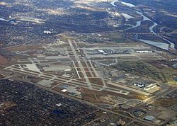
 Aerial photograph of Minneapolis–St. Paul International Airport showing much of the unorganized territory of Fort Snelling. The historic fort is by the confluence of the Mississippi and Minnesota toward the upper right of the photograph, and Fort Snelling National Cemetery is at center right. | |
| Coordinates: 44°53′34″N 93°10′50″W / 44.89278°N 93.18056°W | |
| Country | United States |
| State | Minnesota |
| County | Hennepin County |
| Area | |
• Total | 6.7 sq mi (17.2 km2) |
| • Land | 6.4 sq mi (16.5 km2) |
| • Water | 0.3 sq mi (0.8 km2) |
| Elevation | 860 ft (260 m) |
| Population (2020) | |
• Total | 322 |
| • Density | 48/sq mi (19/km2) |
| Time zone | UTC-6 (Central (CST)) |
| • Summer (DST) | UTC-5 (CDT) |
Fort Snelling is an unorganized territory of Hennepin County in the U.S. state of Minnesota. It is named after historic Fort Snelling, which is located within its boundaries.[1] The district also includes Coldwater Spring park, Fort Snelling National Cemetery, Minneapolis-Saint Paul International Airport, parts of the Mississippi National River and Recreation Area, and several government facilities. As of the 2020 census the territory had a population of 322 people.
- ^ "Unorganized Territory Of Fort Snelling MN Demographic Data and Boundary Map". minnesota.hometownlocator.com. Retrieved 2020-11-02.
