| Fort Snelling State Park | |
|---|---|
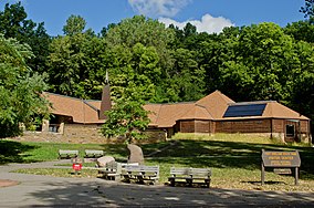
 Thomas C. Savage Interpretive Center | |
| Location | Minnesota, United States |
| Coordinates | 44°53′09″N 93°10′41″W / 44.88583°N 93.17806°W |
| Area | 2,931 acres (11.86 km2) |
| Elevation | 699 ft (213 m)[1] |
| Established | 1962 |
| Named for | Fort Snelling |
| Governing body | Minnesota Department of Natural Resources |
Fort Snelling State Park is a state park of the U.S. state of Minnesota, at the confluence of the Mississippi and Minnesota rivers. For many centuries, the area of the modern park has been of importance to the Mdewakanton Dakota people who consider it the center of the Earth. The state park, which opened in 1962, is named for the historic Fort Snelling, which dates from 1820. The fort structure is maintained and operated by the Minnesota Historical Society. The bulk of the state park preserves the bottomland forest, rivers, and backwater lakes below the river bluffs. Both the state and historic fort structure are part of the Mississippi National River and Recreation Area, a National Park Service site.
As of 2005, the park hosts 400,000 visitors annually and contains the restored fort, a visitor center, 18 miles (29 km) of cross-country skiing trails, 18 miles (29 km) of hiking trails, and 5 miles (8.0 km) of biking trails. These trails connect the park to the Minnesota Valley National Wildlife Refuge, Minnehaha Park, and regional trail systems like the Grand Rounds Scenic Byway and the Big Rivers Regional Trail. Minnesota State Highway 55 crosses over the park on the Mendota Bridge, and many jets taking off and landing at the Minneapolis–Saint Paul International Airport fly directly over the park.

- ^ "Fort Snelling State Park". Geographic Names Information System. United States Geological Survey. 1993-06-01. Retrieved 2011-02-24.

