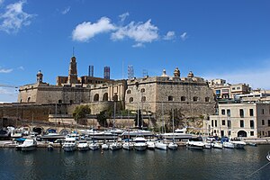
| Fortifications of Senglea | |
|---|---|
Is-Swar tal-Isla | |
| Senglea, Malta | |
 Senglea Land Front | |
 Map of Senglea's fortifications as they are today | |
| Coordinates | 35°53′4.4″N 14°31′8.1″E / 35.884556°N 14.518917°E |
| Type | City wall |
| Site information | |
| Owner | Government of Malta |
| Condition | Partially intact |
| Site history | |
| Built | 1552–18th century |
| Built by | Order of Saint John |
| Materials | Limestone |
| Battles/wars | Great Siege of Malta (1565) Siege of Malta (1798–1800) |
The fortifications of Senglea (Maltese: Is-Swar tal-Isla) are a series of defensive walls and other fortifications which surround the city of Senglea, Malta. The first fortification to be built was Fort Saint Michael in 1552, and the majority of the fortifications were built over the next decade when it was founded by Grand Master Claude de la Sengle. Modifications continued until the 18th century, but large parts of the fortifications were demolished between the 19th and 20th centuries. Today, all that remain of Senglea's fortifications are the seaward bastions and part of the land front.
Senglea's fortifications have been on Malta's tentative list of UNESCO World Heritage Sites since 1998, as part of the Knights' Fortifications around the Harbours of Malta.[1]
- ^ "Knights' Fortifications around the Harbours of Malta". UNESCO Tentative List. Archived from the original on 5 September 2015. Retrieved 16 June 2015.
