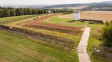
The inner German border was a complex system of interlocking fortifications and security zones 1,381 kilometres (858 mi) long and several kilometres deep, running from the Baltic Sea to Czechoslovakia. The outer fences and walls were the most familiar and visible aspect of the system for Western visitors to the border zone, but they were merely the final obstacle for a would-be escapee from East Germany. The complexity of the border system increased steadily until it reached its full extent in the early 1980s. The following description and the accompanying diagram describe the border as it was around 1980.
Travelling notionally from east to west,[1] an escapee would first reach the edge of the restricted zone (Sperrzone), a closely controlled strip of land 5 kilometres (3.1 mi) wide, running parallel with the border. Evading the patrols and watchful inhabitants of the Sperrzone, the escapee would have reached the first of the border fences. The signal fence (Signalzaun), around 500 to 1,000 metres (1,600 to 3,300 ft) from the actual border, was lined with low-voltage electrified barbed wire which activated alarms when touched or cut.
Beyond the signal fence was the "protective strip" (Schutzstreifen). It was brightly lit by floodlights in many places to reduce an escapee's chances of using the cover of darkness. Guard towers, bunkers and dog runs were positioned at frequent intervals to keep a round-the-clock watch over the strip. Crossing the Schutzstreifen, the escapee would next reach the floodlit control strip, often called the "death strip" in the West. Tripwire-activated flare launchers were situated at various points to help the border guards pinpoint the location of an escape attempt. The last and most formidable obstacle was the outer fencing. In some places there were multiple parallel rows of fences, each up to several metres high, with minefields in between. The fences were not electrified but were booby-trapped with directional anti-personnel mines at intervals of 10 metres (33 ft), each one of which was capable of killing at a range of up to 120 metres (390 ft). Finally, the escapee had to cross whatever natural obstacles were on the western side of the border fence as well as traversing a strip of cleared ground that was up to 500 meters (1640 ft) wide. While crossing this outer strip, the escapee would appear in clear view and shooting range of the border guards before reaching the safety of West German territory.
- ^ Because of the changes in direction of the border, it could also be crossed north to south, south to north or even west to east in some places.

