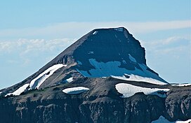
| Fossil Mountain | |
|---|---|
 South aspect | |
| Highest point | |
| Elevation | 10,921 ft (3,329 m)[1] |
| Prominence | 756 ft (230 m)[1] |
| Coordinates | 43°39′13″N 110°55′08″W / 43.65361°N 110.91889°W[2] |
| Geography | |
| Parent range | Teton Range |
| Topo map | USGS Mount Bannon |
Fossil Mountain (10,921 feet (3,329 m)) is located in the Teton Range, within the Jedediah Smith Wilderness of Caribou-Targhee National Forest, U.S. state of Wyoming.[3]
As mapped by J. D. Love and others, the peak of Fossil Mountain consists of relatively flat-lying beds of the Mississippian Madison Limestone and underlying Devonian Darby Formation.[4][5] Underlying the Darby Formation and exposed in shear clifts and floors of glacially modfied valleys are the Ordovician Bighorn Dolomite and Cambrian Gallatin Formation. In all, there is about 2,700 feet (820 m) of lower and middle Paleozoic sedimentary strata exposed within the area of Fossil Mountain.
The study of the sedimentary strata within the Teton Range, shows that these strata consist mostly of limestones and dolomites. The Madison Limestone consists of a basal, dark-colored, fine-grained dolomitic limestones overlain by hundreds of feet of gray limestone that is classified as fossiliferous oosparite and fossiliferous pelsparite.[6] Abundant fossils of shells and corals, which are protected by federal laws, have been found in the Madison Limestone at Fossil Mountain.[7] Underlying the Madison Limestone, the Darby Formation consists predominantly of dolomites and limestones that commonly contain discontinous layers of calcareous shale or sandstone.[6]
- ^ a b "Fossil Mountain, Wyoming". Peakbagger.com. Retrieved 2011-09-18.
- ^ "Fossil Mountain". Geographic Names Information System. United States Geological Survey, United States Department of the Interior. Retrieved 2011-09-18.
- ^ Mount Bannon, WY (Map). TopoQwest (United States Geological Survey Maps). Retrieved 2011-09-18.
- ^ Reed, J.C. and Love, J.D., 1971, Preliminary geologic map of the Mount Bannon quadrangle, Teton County, Wyoming , Open-File Report OF-71-233, 1:24,000, one sheet. Reston, Virginia, U.S. Geological Survey.
- ^ Love, J.D., Reed Jr, J.C. and Christiansen, A.C., 1992. Geologic map of Grand Teton National Park, Teton County, Wyoming, Miscellaneous Investigations Series Map. I-2031, 1:62,500, one sheet. Reston, Virginia, U.S. Geological Survey.
- ^ a b Dixon, J.R. and Reeves, C.C., 1965. Representative carbonate petrography of some lower and middle Paleozoic rocks, west flank Teton Mountains, Wyoming. Journal of Sedimentary Research, 35(3), pp.704-72.
- ^ Schiess, B., 2014. Fossil Mountain and Caves of Darby Canyon, reporter1, Aug 28, 2014, Standard Journal, Madison County, Wyoming, last accessed August 20, 2024.
