| Browns Peak | |
|---|---|
| Yavapai: Wikopa | |
 View of Four Peaks with some snow | |
| Highest point | |
| Elevation | 7,659 ft (2,334 m) NAVD 88[1] |
| Prominence | 3,297 ft (1,005 m)[2] |
| Listing | Arizona county high point[3] |
| Coordinates | 33°41′04″N 111°19′32″W / 33.684357033°N 111.325686994°W[1] |
| Geography | |
 Browns Peak | |
| Location | Gila / Maricopa counties, Arizona, U.S. |
| Parent range | Mazatzal Mountains |
| Topo map | USGS Four Peaks |
| Climbing | |
| Easiest route | Exposed scramble, class 3 |
Four Peaks (Yavapai: Wi:khoba[4]) is a prominent landmark on the eastern skyline of Phoenix. Part of the Mazatzal Mountains, it is located in the Four Peaks Wilderness[5] in the Tonto National Forest, 40 miles (64 km) east-northeast of Phoenix. In winter, Four Peaks offers much of the Phoenix metro area a view of snow-covered peaks. Four Peaks is the site of an amethyst mine that produces top-grade amethyst.
The name Four Peaks is a reference to the four distinct peaks of a north–south ridge forming the massif's summit. The northernmost peak is named Brown's Peak and is the tallest of the four at 7,659 feet (2,334 m).[1] It is the highest point in Maricopa County. The remaining summits have no official names, and from north to south are 7,644 feet (2,330 m),[6] 7,574 feet (2,309 m)[7] and 7,526 feet (2,294 m)[8] in elevation.
-
 View of other three peaks from Browns Peak
 -
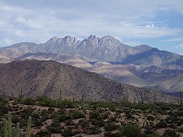 View from desert floor of Four Peaks


- ^ a b c "Four Peaks". NGS Data Sheet. National Geodetic Survey, National Oceanic and Atmospheric Administration, United States Department of Commerce. Retrieved 2014-02-04.
- ^ "Browns Peak". Peakbagger.com. Retrieved 2014-02-04.
- ^ "Arizona County High Points". Peakbagger.com. Retrieved 2016-08-16.
- ^ Alan William Shaterian (1983), Phonology and Dictionary of Yavapai, University of California, Berkeley
- ^ "Four Peaks Wilderness". Wilderness.net. Retrieved 2014-02-04.
- ^ "Four Peaks North Middle, Arizona". Peakbagger.com. Retrieved 2014-02-04.
- ^ "Four Peaks South Middle, Arizona". Peakbagger.com. Retrieved 2014-02-04.
- ^ "Four Peaks South, Arizona". Peakbagger.com. Retrieved 2014-02-04.