Fourmies | |
|---|---|
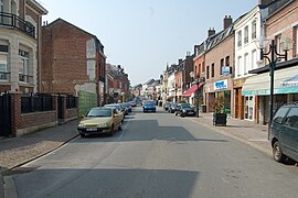
 A view within Fourmies | |
| Coordinates: 50°01′05″N 4°03′14″E / 50.0181°N 4.0539°E | |
| Country | France |
| Region | Hauts-de-France |
| Department | Nord |
| Arrondissement | Avesnes-sur-Helpe |
| Canton | Fourmies |
| Intercommunality | CC Sud Avesnois |
| Government | |
| • Mayor (2020–2026) | Mickaël Hiraux[1] |
Area 1 | 22.98 km2 (8.87 sq mi) |
| Population (2021)[2] | 11,456 |
| • Density | 500/km2 (1,300/sq mi) |
| Time zone | UTC+01:00 (CET) |
| • Summer (DST) | UTC+02:00 (CEST) |
| INSEE/Postal code | 59249 /59610 |
| Elevation | 174–247 m (571–810 ft) (avg. 202 m or 663 ft) |
| 1 French Land Register data, which excludes lakes, ponds, glaciers > 1 km2 (0.386 sq mi or 247 acres) and river estuaries. | |
Fourmies (French pronunciation: [fuʁmi]) is a commune in the Nord department in northern France.[3] The inhabitants are called Fourmisiens. It lies on the river Helpe Mineure (Helpe Minor or Little Helpe). Since 2015, Fourmies has been the seat of the Canton of Fourmies, an administrative division of the Nord department. The canton was created at the French canton reorganization which came into effect in March 2015.[4]
- ^ "Répertoire national des élus: les maires" (in French). data.gouv.fr, Plateforme ouverte des données publiques françaises. 13 September 2022.
- ^ "Populations légales 2021" (in French). The National Institute of Statistics and Economic Studies. 28 December 2023.
- ^ Commune de Fourmies (59249), INSEE
- ^ "Décret n° 2014-167 du 17 février 2014 portant délimitation des cantons dans le département du Nord | Legifrance". Retrieved 15 May 2017.


