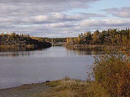
| Frame Lake | |
|---|---|
 Lake in summer 2005 | |
| Location | Yellowknife, Northwest Territories, Canada |
| Coordinates | 62°27′14″N 114°23′24″W / 62.454°N 114.390°W |
| Type | Endorheic |
| Etymology | Bill Frame, early miner and businessman[1] |
| Primary inflows | Two unnamed local streams |
| Primary outflows | Seepage |
| Surface area | 84 hectares (210 acres)[2] |
| Max. depth | 6.5 metres (21 ft)[2] |
| Surface elevation | 186 metres (610 ft)[3] |
| Frozen | Winter |
| Islands | 5 |
| Settlements | Yellowknife |
Frame Lake is located in Yellowknife, Northwest Territories, Canada. It is an 84-hectare (210-acre) endorheic[2] freshwater body located between the city's downtown section and a larger residential area. The Frame Lake Trail circles it, and city hall and the territorial legislative assembly building are on its shores.
Formed by meltwater after the end of the Wisconsin glaciation 20,000 years ago, Frame has been an important part of Yellowknife's history. The Dene in the area used it as a fishing spot before European settlement. In the early years of the city's growth, gold mines nearby dumped tailings in it and sometimes sewage. Later, when the city's New Town, now its downtown section, was surveyed and developed nearby, Frame offered accessible swimming and boating opportunities.
However, storm sewers diverted much of the runoff that fed it.[4] Later development blocked the lake's only outflow, leaving it endorheic[Note 1] and complicating the problems caused by earlier pollution. By the early 1970s it no longer supported any fish; within two decades residents had stopped swimming or boating it out of fear of leeches.[5] Subsequent studies have shown that the lake completely eutrophied sometime in the mid-1990s. They have not, however, been able to determine whether that was due to climate change, pollution or some combination of both; the possibility exists that the lake has always been at a higher trophic state than others in the area.
Some city residents have agitated for efforts to reclaim the lake so it will once again be a destination for swimmers, anglers and boaters in warm weather. To do so, it will be necessary to reoxygenate the water to the point that fish can again inhabit its waters. This could be accomplished either by aeration or dredging, which would remove the accumulated rotted organic matter on the lake bed that currently renders it anoxic when the lake is frozen over in the winter.
- ^ "Yellowknife Heritage Map" (PDF). City of Yellowknife. Retrieved October 10, 2015.
- ^ a b c Healey, M.C.; Woodall, W.L. (1973). "Technical report No. 407: Limnological Surveys of Seven Lakes Near Yellowknife, Northwest Territories" (PDF). Fisheries Research Board of Canada. p. 3. Retrieved October 5, 2015.
- ^ The Atlas of Canada (Map). 1:17,500. Cartography by Natural Resources Canada. Government of Canada. Retrieved October 6, 2015.
- ^ Wolfe, Stephen, ed. (1998). "Living with Frozen Ground: A Field Guide to Permafrost in Yellowknife, Northwest Territories (Geological Survey of Canada, Miscellaneous Report 64)" (PDF). Natural Resources Canada. p. 43. Retrieved October 6, 2015.
- ^ "Yellowknife's Frame Lake oxygen levels too low for fish, say scientists". Canadian Broadcasting Corporation (CBC). July 13, 2015. Retrieved October 6, 2015.
Cite error: There are <ref group=Note> tags on this page, but the references will not show without a {{reflist|group=Note}} template (see the help page).
