Francistown | |
|---|---|
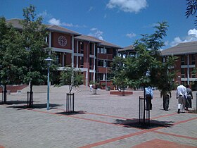
Top to bottom: Institute of Health Sciences in Francistown CBD, Phillip Gaonwe Matante International Airport, Obed Itani Chilume Stadium | |
Map of Botswana showing Francistown | |
| Coordinates: 21°10′25″S 27°30′45″E / 21.17361°S 27.51250°E | |
| Country | |
| District | North-East District |
| Founded | 1897 |
| Incorporated as a city | 1997 |
| Named for | Daniel Francis |
| Government | |
| • Type | City commission government |
| • Body | City of Francistown Council |
| • Mayor | Godisang Radisigo (BDP) |
| Area | |
• City | 79 km2 (31 sq mi) |
| Elevation | 1,001 m (3,284 ft) |
| Population (2022 census)[1] | |
• City | 103,417 |
| • Density | 1,300/km2 (3,400/sq mi) |
| • Metro | 147,122 |
| Time zone | UTC+2 (Central Africa Time) |
| • Summer (DST) | UTC+2 (not observed) |
| Geographical area code[2][3] | 2XX |
| ISO 3166 code | BW-FR |
| Climate | BSh |
Francistown is the second-largest city in Botswana, with a population of about 103,417 and 147,122 inhabitants for its agglomeration at the 2022 census.[4] It is located in eastern Botswana, about 400 kilometres (250 mi) north-northeast from the capital, Gaborone. Francistown is located at the confluence of the Tati and Ntshe rivers, and near the Shashe River (tributary to the Limpopo) and 90 kilometres (56 mi) from the international border with Zimbabwe.
Francistown was the centre of Southern Africa's first gold rush and is still surrounded by old and abandoned mines. The City of Francistown is an administrative district, separated from North-East District. It is administered by Francistown City Council.[5] The main language spoken and used in and around Francistown is Kalanga. Other languages used in the area are isiNdebele, ChiShona as well as SeTswana. Francistown is the only city in Botswana with an English name. There are no English-language named towns and only a couple of villages with English names.
- ^ "Statistics Botswana - Census 2022 - Population of cities, towns and villages" (PDF).
- ^ Current local time and date in Gaborone, Botswana, timeanddate.com. Accessed 12: July 2023.
- ^ Botswana Telecommunications Authority (11 September 2009). Botswana (country code +267). International Telecommunication Union. Archived from the original (DOC) on 27 December 2009. Retrieved 27 December 2009.
{{cite book}}:|work=ignored (help) - ^ Central Statistics Office (January 2009). "BOTSWANA DEMOGRAPHIC SURVEY 2006" (PDF). Gaborone, Botswana. Archived from the original (PDF) on 23 September 2016. Retrieved 25 July 2010.
- ^ Laws of Botswana Archived 23 July 2011 at the Wayback Machine, Ministry of Local Government Archived 18 July 2009 at the Wayback Machine


