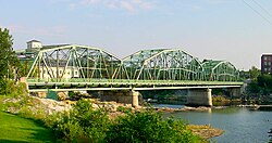
Frank J. Wood Bridge | |
|---|---|
 Frank J. Wood Bridge c. 2021 | |
| Coordinates | 43°55′16″N 69°57′57″W / 43.92111°N 69.96583°W |
| Carries |
|
| Crosses | Androscoggin River |
| Locale | Topsham/Brunswick, Maine |
| Other name(s) | Green Bridge |
| Named for | Frank J. Wood |
| Owner | Maine |
| Maintained by | Maine Department of Transportation |
| Heritage status | Eligible for the National Register of Historic Places |
| ID number | ME 2016 |
| Preceded by | Androscoggin Swinging Bridge |
| Followed by | Maine State Route 196 |
| Characteristics | |
| Design | Through Truss |
| Material | Steel and Concrete |
| Total length | 815 ft (248 m) |
| Width | 30.8 ft (9.4 m) |
| Longest span | 310.1 ft (94.5 m) |
| No. of spans | 3 |
| Load limit | 10 short tons (9.1 t) |
| Clearance above | 15.7 ft (4.8 m) |
| Clearance below | 23 ft (7.0 m) |
| No. of lanes | 2 |
| History | |
| Constructed by | Boston Bridge Works |
| Built | 1932 |
| Construction cost | 300,000 United States dollars |
| Rebuilt |
|
| Replaces | Brunswick-Topsham Bridge |
| Statistics | |
| Daily traffic | 19,400 vehicles (2010) |
| Location | |
 | |
| References | |
| National Bridge Inventory[1] | |
The Frank J. Wood Bridge (known locally as The Green Bridge) is a three span, through truss bridge crossing over the Androscoggin River between the towns of Topsham and Brunswick, Maine, on U.S. Route 201. Opened in 1932, the bridge was originally called the Brunswick-Topsham bridge (as was its predecessor) but was officially renamed the Frank J. Wood Bridge, after a local farmer who suggested the location.
The bridge has met requirements to be considered for the National Register of Historic Places, both as a standalone historic site and as a component of the Brunswick Commercial Historic District. Despite its eligibility, the Maine Department of Transportation (MaineDOT) has initiated the building of a new bridge that will replace the deteriorating Frank J. Wood Bridge by 2025.
- ^ "National Bridge Inventory Data Sheet" (PDF). historicbridges.org. 2011. Archived (PDF) from the original on May 22, 2022. Retrieved September 10, 2023 – via Federal Highway Administration.