Franklin County | |
|---|---|
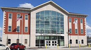
 Franklin County Courthouse in Benton | |
 Location within the U.S. state of Illinois | |
 Illinois's location within the U.S. | |
| Coordinates: 37°59′N 88°55′W / 37.99°N 88.92°W | |
| Country | |
| State | |
| Founded | January 2, 1818 |
| Named for | Benjamin Franklin |
| Seat | Benton |
| Largest city | West Frankfort |
| Area | |
| • Total | 432 sq mi (1,120 km2) |
| • Land | 409 sq mi (1,060 km2) |
| • Water | 23 sq mi (60 km2) 5.2% |
| Population (2020) | |
| • Total | 37,804 |
| • Estimate (2023) | 37,138 |
| • Density | 88/sq mi (34/km2) |
| Time zone | UTC−6 (Central) |
| • Summer (DST) | UTC−5 (CDT) |
| Congressional district | 12th |
| Website | www |
Franklin County is a county in Southern Illinois. At the 2020 census, it had a population of 37,804.[1] The largest city is West Frankfort and the county seat is Benton.[2] This area of Southern Illinois is known locally as "Little Egypt".
- ^ "State & County QuickFacts". United States Census Bureau. Archived from the original on June 6, 2011. Retrieved July 5, 2014.
- ^ "Find a County". National Association of Counties. Archived from the original on May 31, 2011. Retrieved June 7, 2011.
