| Franz Josef Glacier / Kā Roimata o Hine Hukatere | |
|---|---|
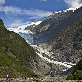
 Franz Josef Glacier in 2011 | |
| Location | Westland Tai Poutini National Park |
| Coordinates | 43°28′01″S 170°11′30″E / 43.46694°S 170.19167°E |
| Length | 12 km (7.5 mi) |
| Thickness | Up to 300 metres (980 ft) thick |
| Status | Retreating |
The Franz Josef Glacier (Māori: Kā Roimata o Hine Hukatere; officially Franz Josef Glacier / Kā Roimata o Hine Hukatere) is a 12-kilometre-long (7.5 mi)[1] temperate maritime glacier in Westland Tai Poutini National Park on the West Coast of New Zealand's South Island. Together with the Fox Glacier 20 kilometres (12 mi) to the south, and a third glacier, it descends from the Southern Alps to less than 300 metres (980 ft) above sea level.[2]
The area surrounding the two glaciers is part of Te Wāhipounamu, a World Heritage Site park. The Waiho River emerges from the glacier terminal of Franz Josef.[3]
- ^ "Glaciers in New Zealand". Te Ara: The Encyclopedia of New Zealand. Retrieved 16 January 2008.
- ^ "Franz Josef Glacier/Kā Roimata o Hine Hukatere". DOC. Retrieved 14 May 2008.
- ^ Cite error: The named reference
MINENwas invoked but never defined (see the help page).
