Fredonia, Wisconsin | |
|---|---|
 Looking east in downtown Fredonia | |
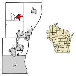
 Location of Fredonia in Ozaukee County, Wisconsin. | |
| Coordinates: 43°28′6″N 87°57′6″W / 43.46833°N 87.95167°W | |
| Country | |
| State | |
| County | Ozaukee |
| Settled | 1840s |
| Incorporated | 1922 |
| Government | |
| • Village President | Dan Gehrke |
| • Treasurer | Melissa Depies |
| • Village Board | Trustees
|
| • Village Administrator | Christophe E. Jenkins |
| Area | |
• Total | 2.14 sq mi (5.55 km2) |
| • Land | 2.13 sq mi (5.53 km2) |
| • Water | 0.01 sq mi (0.02 km2) |
| Elevation | 896 ft (273 m) |
| Population | |
• Total | 2,160 |
• Estimate (2019)[4] | 2,253 |
| • Density | 1,055.76/sq mi (407.67/km2) |
| Time zone | UTC-6 (Central (CST)) |
| • Summer (DST) | UTC-5 (CDT) |
| Area code | 262 |
| FIPS code | 55-27575[5] |
| GNIS feature ID | 1565286[2] |
| Website | village |
Fredonia is a village in Ozaukee County, Wisconsin, United States. Located on the Milwaukee River, the village is in the Milwaukee metropolitan area. The population was 2,160 at the 2010 census.
The community was the site of a Potawatomi village until at least the 1840s. The first white settlers in the area were Yankees, Germans and Luxembourgers who arrived in the 1840s, but the community was rural until the 1870s when the Chicago, Milwaukee & St. Paul Railway built a station in the area and businesses began to cluster it, laying the foundation for the village. Fredonia grew, incorporating in 1922.
The village is located east of the unincorporated census-designated place of Waubeka, the location of the National Register of Historic Places-listed Stony Hill School where the first United States Flag Day was observed in 1885. Today, Waubeka is home to the National Flag Day Foundation headquarters and its Americanism Center Museum, which has an extensive collection of patriotic memorabilia.[6]
- ^ "2019 U.S. Gazetteer Files". United States Census Bureau. Retrieved August 7, 2020.
- ^ a b "US Board on Geographic Names". United States Geological Survey. October 25, 2007. Retrieved January 31, 2008.
- ^ Cite error: The named reference
wwwcensusgovwas invoked but never defined (see the help page). - ^ Cite error: The named reference
USCensusEst2019CenPopScriptOnlyDirtyFixDoNotUsewas invoked but never defined (see the help page). - ^ "U.S. Census website". United States Census Bureau. Retrieved January 31, 2008.
- ^ "National Flag Day Foundation". National Flag Day Foundation. Retrieved May 18, 2020.