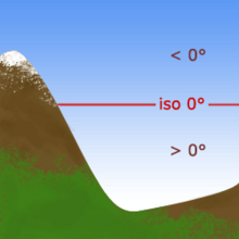
The freezing level, or 0 °C (zero-degree) isotherm, represents the altitude in which the temperature is at 0 °C (the freezing point of water) in a free atmosphere (i.e. allowing reflection of the sun by snow, icing conditions, etc.). Any given measure is valid for only a short period of time, often less than a day as variations in wind, sunlight, air masses and other factors may change the level. The 700 hPa pressure level (or about 3000 m above sea level) is generally assumed as a rough estimate of the freezing level.
Above the freezing altitude, the temperature of the air is below freezing. Below it, the temperature is above freezing. The profile of this frontier, and its variations, are studied in meteorology, and are used for a variety of forecasts and predictions, especially in cold weather. Whilst not given on general weather forecasts, it is used on bulletins giving forecasts for mountainous areas.